IMAGES TAKEN NEAR TO
Coriander Way, OXFORD, OX4 7XY
Introduction
This page details the photographs taken nearby to Coriander Way, OX4 7XY by members of the Geograph project.
The Geograph project started in 2005 with the aim of publishing, organising and preserving representative images for every square kilometre of Great Britain, Ireland and the Isle of Man.

There are currently over 7.5m images from over14,400 individuals and you can help contribute to the project by visiting https://www.geograph.org.uk
Image Map
Images are licensed for reuse under creativecommons.org/licenses/by-sa/2.0
Notes
- Clicking on the map will re-center to the selected point.
- The higher the marker number, the further away the image location is from the centre of the postcode.
Image Listing (5 Images Found)
Images are licensed for reuse under creativecommons.org/licenses/by-sa/2.0
Image
Details
Distance
1
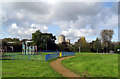
Playground in Gillians Park
Looking towards Evenlode and Windrush towers, Blackbird Leys.
Image: © Des Blenkinsopp
Taken: 20 Oct 2010
0.12 miles
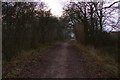
3
Windale Primary School
Windale Primary School Greater Leys
Image: © Shaun Ferguson
Taken: 28 Jun 2009
0.23 miles
4

Pylon near Sandford Brake
One of the five transmission lines which converge at the large sub-station at Sandford Brake, near Cowley.
Image: © David Hawgood
Taken: 23 Jun 2006
0.24 miles