IMAGES TAKEN NEAR TO
Ashmole Place, OXFORD, OX4 6TF
Introduction
This page details the photographs taken nearby to Ashmole Place, OX4 6TF by members of the Geograph project.
The Geograph project started in 2005 with the aim of publishing, organising and preserving representative images for every square kilometre of Great Britain, Ireland and the Isle of Man.

There are currently over 7.5m images from over14,400 individuals and you can help contribute to the project by visiting https://www.geograph.org.uk
Image Map
Images are licensed for reuse under creativecommons.org/licenses/by-sa/2.0
Notes
- Clicking on the map will re-center to the selected point.
- The higher the marker number, the further away the image location is from the centre of the postcode.
Image Listing (34 Images Found)
Images are licensed for reuse under creativecommons.org/licenses/by-sa/2.0
Image
Details
Distance
1
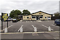
Bullnose Morris
A Hungry Horse public house on Cuddesdon Way.
The name refers to the Bullnose Morris motor car built at the factory just north of here, where the current BMW Mini range is produced.
Image: © David P Howard
Taken: 21 Aug 2014
0.04 miles
2
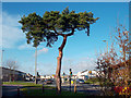
Tree and Traffic Lights
The junction of Watlington Road and Sandy Lane.
Image: © Des Blenkinsopp
Taken: 30 Nov 2011
0.04 miles
4
Mini Works, Gate 10
Looking across the Watlington Road.
Image: © Jonathan Billinger
Taken: 12 Jul 2017
0.09 miles
5
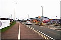
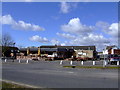
Watlington Road (B480), Cowley, Oxford
There are many large stores here such as Lidl, Topps Tiles and a Halfords Autocentre. In the distance, at the traffic lights, the road on the left is Transport Way.
Image: © P L Chadwick
Taken: 11 Mar 2017
0.11 miles
6

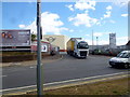
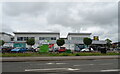
Lidl, Watlington Road, Cowley, Oxford
One of the larger Lidl stores, which has a wider range of items than the majority of its stores. Located on Watlington Road (the B480).
Image: © P L Chadwick
Taken: 11 Mar 2017
0.11 miles
7
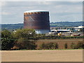
Cowley gasometer (gas-holder)
Gas holder at Cowley viewed over the fields from Garsington
Image: © David Hawgood
Taken: 24 Sep 2006
0.12 miles
8
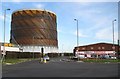
Oxford: Cowley gasometer
On Oxford Road, Cowley, viewed from its junction with the B480 Watlington Road.
Image: © Nigel Cox
Taken: 16 Jan 2008
0.12 miles
10

Isis House, Transport Way
A smart new block reflecting its surroundings, literally if not stylistically. The reflection, I think, is Lidl's supermarket.
Isis is an alternative name for the upper Thames, not actually used much for the river these days but very popular for naming all sorts of other stuff like buildings, businesses, pubs and whatever.
Transport Way leads to the back entrance of BMW's car factory and a big Unipart depot, so it's a fair enough name.
Image: © Des Blenkinsopp
Taken: 30 Nov 2011
0.12 miles