IMAGES TAKEN NEAR TO
Bampton Close, OXFORD, OX4 6NN
Introduction
This page details the photographs taken nearby to Bampton Close, OX4 6NN by members of the Geograph project.
The Geograph project started in 2005 with the aim of publishing, organising and preserving representative images for every square kilometre of Great Britain, Ireland and the Isle of Man.

There are currently over 7.5m images from over14,400 individuals and you can help contribute to the project by visiting https://www.geograph.org.uk
Image Map
Images are licensed for reuse under creativecommons.org/licenses/by-sa/2.0
Notes
- Clicking on the map will re-center to the selected point.
- The higher the marker number, the further away the image location is from the centre of the postcode.
Image Listing (19 Images Found)
Images are licensed for reuse under creativecommons.org/licenses/by-sa/2.0
Image
Details
Distance
3
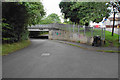
Subway graffiti
The bridge takes Barns Road over Oxford's southern ring road. A cycle path runs parallel to the ring road.
Image: © Bill Boaden
Taken: 4 Jul 2020
0.13 miles
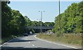
4
Bridge taking Barns Road over cycle path beside Eastern By-Pass
There is an OS rivet benchmark Image on the end of the wall nearest the camera.
Image: © Roger Templeman
Taken: 4 Jun 2011
0.14 miles
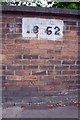
5
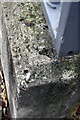
Benchmark on Eastern By-Pass wall at Barns Road junction
Ordnance Survey rivet benchmark described on the Bench Mark Database at http://www.bench-marks.org.uk/bm38190
Image: © Roger Templeman
Taken: 4 Jun 2011
0.14 miles
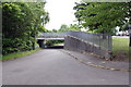
6
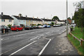
Barns Road
Linking Cowley and Blackbird Leys.
Image: © Bill Boaden
Taken: 4 Jul 2020
0.15 miles
7
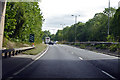
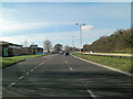
A4142 Eastern Bypass Road
Going anticlockwise around Oxford.
Image: © Robin Webster
Taken: 11 Aug 2019
0.16 miles
9
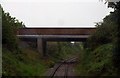
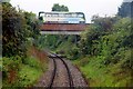
Blackbird Leys Road bridge over the branch line
Image: © Steve Daniels
Taken: 7 May 2011
0.17 miles
10
Benchmark on railway bridge on Blackbird Leys Road
Ordnance Survey cut mark benchmark described on the Bench Mark Database at http://www.bench-marks.org.uk/bm38222
Image: © Roger Templeman
Taken: 4 Jun 2011
0.17 miles