IMAGES TAKEN NEAR TO
Knights Road, OXFORD, OX4 6HY
Introduction
This page details the photographs taken nearby to Knights Road, OX4 6HY by members of the Geograph project.
The Geograph project started in 2005 with the aim of publishing, organising and preserving representative images for every square kilometre of Great Britain, Ireland and the Isle of Man.

There are currently over 7.5m images from over14,400 individuals and you can help contribute to the project by visiting https://www.geograph.org.uk
Image Map
Images are licensed for reuse under creativecommons.org/licenses/by-sa/2.0
Notes
- Clicking on the map will re-center to the selected point.
- The higher the marker number, the further away the image location is from the centre of the postcode.
Image Listing (21 Images Found)
Images are licensed for reuse under creativecommons.org/licenses/by-sa/2.0
Image
Details
Distance
1
The top of a 1960s tower block in Blackbird Leys viewed from the Holiday Inn Express
The tower block is to the left of centre. On the far left is part of the Kassam Stadium.
Image: © Roger A Smith
Taken: 7 Sep 2019
0.01 miles
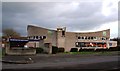
4
The Blackbird on Blackbird Leys Road
The Blackbird is a Greene King pub.
Image: © Steve Daniels
Taken: 10 Jan 2016
0.03 miles

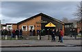
7
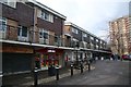
Shops and maisonettes on Blackbird Leys Road
Image: © Steve Daniels
Taken: 10 Jan 2016
0.06 miles
8
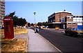
Knights Road, Blackbird Leys
Looking towards the local shops
Image: © David Howard
Taken: 3 Aug 2019
0.06 miles
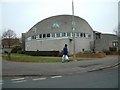
9
Church of the Holy Family on Blackbird Leys Road
Image: © Steve Daniels
Taken: 10 Jan 2016
0.07 miles
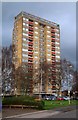
10
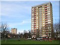
Oxford: Evenlode Tower, Blackbird Leys
The Evenlode Tower, and its sister, the Windrush Tower, visible to the left in the photo, are 15 storey tower blocks built in the early 1960s on Blackbird Leys Road and named after rivers that flow into the Thames near Oxford. Each block has 60 flats. The tower blocks do not fit in with Oxford City Council's long term vision for social housing, and could possibly be demolished within the next fifteen years.
Image: © Nigel Cox
Taken: 16 Jan 2008
0.14 miles