IMAGES TAKEN NEAR TO
Poulton Place, OXFORD, OX4 6BW
Introduction
This page details the photographs taken nearby to Poulton Place, OX4 6BW by members of the Geograph project.
The Geograph project started in 2005 with the aim of publishing, organising and preserving representative images for every square kilometre of Great Britain, Ireland and the Isle of Man.

There are currently over 7.5m images from over14,400 individuals and you can help contribute to the project by visiting https://www.geograph.org.uk
Image Map
Images are licensed for reuse under creativecommons.org/licenses/by-sa/2.0
Notes
- Clicking on the map will re-center to the selected point.
- The higher the marker number, the further away the image location is from the centre of the postcode.
Image Listing (24 Images Found)
Images are licensed for reuse under creativecommons.org/licenses/by-sa/2.0
Image
Details
Distance
1
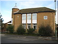
Oxford: Church of the Sacred Heart, Blackbird Leys
Situated on Balfour Road at its junction with Sawpit Road, this is the Sawpit Road façade. The Church's website is here http://www.communigate.co.uk/oxford/rcchurch/page10.phtml
Image: © Nigel Cox
Taken: 16 Jan 2008
0.08 miles
2
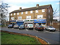
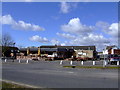
Oxford: Balfour Road, Blackbird Leys
Neighbourhood shopping parade, that may contain the first shops to open on the Blackbird Leys estate around 1958.
Image: © Nigel Cox
Taken: 16 Jan 2008
0.08 miles
4
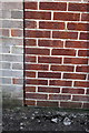
Benchmark on #160 Sandy Lane
Ordnance Survey cut mark benchmark described on the Bench Mark Database at http://www.bench-marks.org.uk/bm38226
Image: © Roger Templeman
Taken: 4 Jun 2011
0.13 miles
6
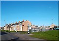
A Street in Blackbird Leys
Blackbird Leys is a new suburb to the south east of Oxford.
Image: © Des Blenkinsopp
Taken: 30 Nov 2011
0.16 miles
7
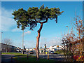
Tree and Traffic Lights
The junction of Watlington Road and Sandy Lane.
Image: © Des Blenkinsopp
Taken: 30 Nov 2011
0.19 miles
9
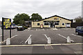
Bullnose Morris
A Hungry Horse public house on Cuddesdon Way.
The name refers to the Bullnose Morris motor car built at the factory just north of here, where the current BMW Mini range is produced.
Image: © David P Howard
Taken: 21 Aug 2014
0.20 miles