IMAGES TAKEN NEAR TO
Padua Way, OX4 4WA
Introduction
This page details the photographs taken nearby to Padua Way, OX4 4WA by members of the Geograph project.
The Geograph project started in 2005 with the aim of publishing, organising and preserving representative images for every square kilometre of Great Britain, Ireland and the Isle of Man.

There are currently over 7.5m images from over14,400 individuals and you can help contribute to the project by visiting https://www.geograph.org.uk
Image Map
Images are licensed for reuse under creativecommons.org/licenses/by-sa/2.0
Notes
- Clicking on the map will re-center to the selected point.
- The higher the marker number, the further away the image location is from the centre of the postcode.
Image Listing (19 Images Found)
Images are licensed for reuse under creativecommons.org/licenses/by-sa/2.0
Image
Details
Distance
1
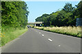
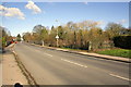
A4074 towards Oxford
The bridge carries Sandford Road between Sandford and Littlemore.
Image: © Robin Webster
Taken: 18 Jul 2021
0.11 miles
2
A4074 towards Oxford
The bridge carries Sandford Road between Sandford and Littlemore.
Image: © Robin Webster
Taken: 11 Aug 2019
0.12 miles
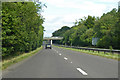
3
A4074 crossed by the Sandford Road bridge
Image: © Stuart Logan
Taken: 4 Feb 2012
0.12 miles
4
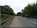
Sandford Road bridging the A4074
Towards Littlemore.
Image: © JThomas
Taken: 26 Jul 2022
0.12 miles
5
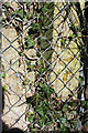
Benchmark on concrete fence post, Sandford Road
The Ordnance Survey cut mark benchmark on the right hand post is described on the Bench Mark Database at http://www.bench-marks.org.uk/bm47051
Image: © Roger Templeman
Taken: 2 Feb 2013
0.12 miles
6
Sandford Road where it crosses over the A4074
There is an OS benchmark Image on the ivy-covered fence post at the fence angle by the pavement on the right hand side of the road.
Image: © Roger Templeman
Taken: 2 Feb 2013
0.13 miles
7

Fletcher and Winchester House
So new it's not on the map. Part of Oxford science park, this giant building is in two parts. Fletcher is the nearer.
Image: © Des Blenkinsopp
Taken: 17 Feb 2010
0.15 miles
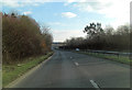
8
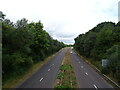
A4074 towards Oxford
From the bridge on Sandford Road.
Image: © JThomas
Taken: 26 Jul 2022
0.16 miles
10

Lake at Oxford Science Park
There are still undeveloped sites on the Park, but the blocks around this lake look quite well established and make for good pictures on a clear afternoon.
Unfortunately, some security guy turned up and started giving me grief about taking photos here.
No idea why. Something about some of the tenants not wanting to be photographed. Sounds a bit dodgy if you ask me, and anyway, you can't keep an office block a secret for long.
He was probably bored, but best keep your camera under your jacket if you try your luck here.
Image: © Des Blenkinsopp
Taken: 17 Feb 2010
0.17 miles