IMAGES TAKEN NEAR TO
Armstrong Road, OX4 4QY
Introduction
This page details the photographs taken nearby to Armstrong Road, OX4 4QY by members of the Geograph project.
The Geograph project started in 2005 with the aim of publishing, organising and preserving representative images for every square kilometre of Great Britain, Ireland and the Isle of Man.

There are currently over 7.5m images from over14,400 individuals and you can help contribute to the project by visiting https://www.geograph.org.uk
Image Map
Images are licensed for reuse under creativecommons.org/licenses/by-sa/2.0
Notes
- Clicking on the map will re-center to the selected point.
- The higher the marker number, the further away the image location is from the centre of the postcode.
Image Listing (8 Images Found)
Images are licensed for reuse under creativecommons.org/licenses/by-sa/2.0
Image
Details
Distance
1
Brook and Bridge
This is the Littlemore Brook in Oxford Science Park.
Image: © Des Blenkinsopp
Taken: 3 Sep 2010
0.12 miles
2

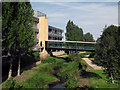
Fletcher and Winchester House
So new it's not on the map. Part of Oxford science park, this giant building is in two parts. Fletcher is the nearer.
Image: © Des Blenkinsopp
Taken: 17 Feb 2010
0.13 miles
3

Lake at Oxford Science Park
There are still undeveloped sites on the Park, but the blocks around this lake look quite well established and make for good pictures on a clear afternoon.
Unfortunately, some security guy turned up and started giving me grief about taking photos here.
No idea why. Something about some of the tenants not wanting to be photographed. Sounds a bit dodgy if you ask me, and anyway, you can't keep an office block a secret for long.
He was probably bored, but best keep your camera under your jacket if you try your luck here.
Image: © Des Blenkinsopp
Taken: 17 Feb 2010
0.14 miles
4
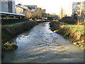
Littlemore Brook in the Oxford Science Park
Littlemore Brook is a tributary of the River Thames that flows down from the Blackbird Leys estate. It is seen here looking downstream from a footbridge in the Oxford Science Park.
Image: © Nigel Cox
Taken: 16 Jan 2008
0.16 miles
5
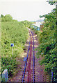
Single track towards the Cowley Works
Below the Sandford Road Bridge the single track heads towards the BMW Cowley works
Image: © Shaun Ferguson
Taken: 7 Dec 2008
0.18 miles
6

Oxford Science Park
The Oxford Science Park is a joint venture development between Magdalen College and Prudential Insurance. Behind the fountain is the Danby Building, an office block completed in 2002, while to the right is the Sherard Building, also offices and also completed in 2002. The Oxford Science Park's website is here http://www.oxfordsp.com/aboutus_introduction.html
Image: © Nigel Cox
Taken: 16 Jan 2008
0.19 miles
8
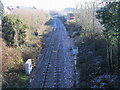
Site of former Littlemore station, 2004
View SE from the (former A423) road bridge, towards Morris Cowley, Thame and Princes Risborough: ex-GWR (Wycombe Railway) (Oxford) Kennington Junction - Princes Risborough line. Littlemore station was closed 7/1/63 to passengers when these services ceased on the whole line, but remained for goods until 21/6/71 and the line remains open Kennington Junction - Morris Cowley to serve the BMW-Mini car factory. The rest of the line has gone: Morris Cowley - Thame since 1/5/67, Thame - Princes Risborough since 17/4/91.
Image: © Ben Brooksbank
Taken: 1 Jul 2004
0.23 miles