IMAGES TAKEN NEAR TO
St. Nicholas Road, OXFORD, OX4 4PW
Introduction
This page details the photographs taken nearby to St. Nicholas Road, OX4 4PW by members of the Geograph project.
The Geograph project started in 2005 with the aim of publishing, organising and preserving representative images for every square kilometre of Great Britain, Ireland and the Isle of Man.

There are currently over 7.5m images from over14,400 individuals and you can help contribute to the project by visiting https://www.geograph.org.uk
Image Map
Images are licensed for reuse under creativecommons.org/licenses/by-sa/2.0
Notes
- Clicking on the map will re-center to the selected point.
- The higher the marker number, the further away the image location is from the centre of the postcode.
Image Listing (33 Images Found)
Images are licensed for reuse under creativecommons.org/licenses/by-sa/2.0
Image
Details
Distance
1
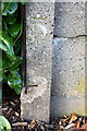
Benchmark on concrete post of Priory Road electricity substation
Ordnance Survey cut mark benchmark described on the Bench Mark Database at http://www.bench-marks.org.uk/bm52477
Image: © Roger Templeman
Taken: 2 Nov 2013
0.03 miles
2
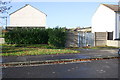
Priory Road electricity substation
There is an OS benchmark Image on the front of the left hand corner post of the ESS enclosure, next to the bush. The houses to the left of the enclosure are on St Nicholas Road
Image: © Roger Templeman
Taken: 2 Nov 2013
0.03 miles
3

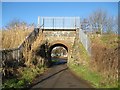
Benchmark on Priory Road railway bridge abutment
Ordnance Survey rivet benchmark described on the Bench Mark Database at http://www.bench-marks.org.uk/bm52459
Image: © Roger Templeman
Taken: 2 Nov 2013
0.17 miles
4
Priory Road railway bridge (17m 04ch THA)
There is an OS benchmark Image on top of the near end of the right hand side bridge abutment wall
Image: © Roger Templeman
Taken: 2 Nov 2013
0.18 miles
5
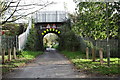
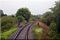
Oxford: Minchery Road railway bridge
This little bridge was originally constructed in the embankment of the former Oxford to Princes Risborough railway line to provide access to Minchery Farm and its sewage works from Littlemore. However the road is now gated and only allows access to the former sewage workers' cottages around to the right. Although most of the railway line to Princes Risborough was lifted in 1963, this stub end remains as a freight line to the Cowley motor works.
Image: © Nigel Cox
Taken: 16 Jan 2008
0.18 miles
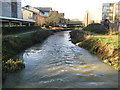
7
Brook and Bridge
This is the Littlemore Brook in Oxford Science Park.
Image: © Des Blenkinsopp
Taken: 3 Sep 2010
0.20 miles
8

Bust of Cardinal Newman in the College garden
Image: © Steve Daniels
Taken: 16 Apr 2009
0.20 miles
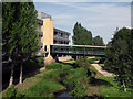
10
Littlemore Brook in the Oxford Science Park
Littlemore Brook is a tributary of the River Thames that flows down from the Blackbird Leys estate. It is seen here looking downstream from a footbridge in the Oxford Science Park.
Image: © Nigel Cox
Taken: 16 Jan 2008
0.21 miles