IMAGES TAKEN NEAR TO
The Towing Path, OXFORD, OX4 4EL
Introduction
This page details the photographs taken nearby to The Towing Path, OX4 4EL by members of the Geograph project.
The Geograph project started in 2005 with the aim of publishing, organising and preserving representative images for every square kilometre of Great Britain, Ireland and the Isle of Man.

There are currently over 7.5m images from over14,400 individuals and you can help contribute to the project by visiting https://www.geograph.org.uk
Image Map
Images are licensed for reuse under creativecommons.org/licenses/by-sa/2.0
Notes
- Clicking on the map will re-center to the selected point.
- The higher the marker number, the further away the image location is from the centre of the postcode.
Image Listing (185 Images Found)
Images are licensed for reuse under creativecommons.org/licenses/by-sa/2.0
Image
Details
Distance
1
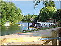
The Isis boathouse
Built in 1905 as a boatbuilder's premises, it is now a boathouse with a private house above. Shakespeare's Way passes along the towpath here.
Image: © Graham Horn
Taken: 6 Apr 2013
0.00 miles
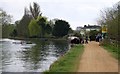
2
Towpath on Isis with racing eights about to start
Image: © Roger Davies
Taken: 27 May 2009
0.00 miles
3
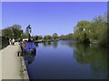
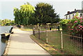
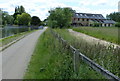
Towards Iffley Lock, South Oxford
A summer's evening near Iffley Lock with St Mary's Church, Iffley in the distance. "The Isis Farmhouse" licensed café sits on the towpath ahead on the right-hand side. Donnington Bridge and its load - i.e. the B4495 - and Oxford lie behind the photographer.
Image: © David Hallam-Jones
Taken: 30 Jul 2013
0.00 miles
4
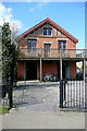
Iffley Lock Vicinity, Oxford
It was reported in “The Oxford News” on 6th March 2008 that a part-time psychiatrist and former corporate lawyer and his wife had bought the former and neglected “Isis Tavern” near Iffley Lock with a view to bringing it to life again. The couple, who had moved into the nearby Isis boathouse three years earlier and opened a cafe in it, have – it seems – now reopened this former pub as a licensed riverside cafe having renamed it “The Isis Farmhouse”. The establishment can only be reached by bicycle, foot or boat, something that applies to suppliers as well as customers. Also, it is only open Thursdays to Sundays. Iffley Lock lies a further 5-10 minutes walk ahead.
Image: © David Hallam-Jones
Taken: 30 Jul 2013
0.00 miles
5
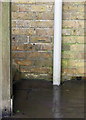
Benchmark on Isis Boathouse
Ordnance Survey cut mark benchmark described on the Bench Mark Database at http://www.bench-marks.org.uk/bm54784
Image: © Roger Templeman
Taken: 24 Feb 2014
0.01 miles
6
Isis Boathouse
This is a functioning boathouse, built in 1905 as a boat builders, and now housing rowing boats, canoes and kayaks on the ground floor, and a private home on the first floor. The owners also own the nearby Isis Farmhouse Image
Image: © N Chadwick
Taken: 22 Feb 2014
0.01 miles
7
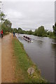
Isis Boat House along the River Thames
Looking south along the Thames Path.
Image: © Mat Fascione
Taken: 15 Jun 2015
0.01 miles
8
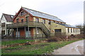
Isis Boathouse beside the Thames north of Iffley Lock
There is an OS benchmark Image on the side of the building near the bottom of the wooden steps
Image: © Roger Templeman
Taken: 24 Feb 2014
0.01 miles