IMAGES TAKEN NEAR TO
Nuneham Park, OXFORD, OX44 9PW
Introduction
This page details the photographs taken nearby to Nuneham Park, OX44 9PW by members of the Geograph project.
The Geograph project started in 2005 with the aim of publishing, organising and preserving representative images for every square kilometre of Great Britain, Ireland and the Isle of Man.

There are currently over 7.5m images from over14,400 individuals and you can help contribute to the project by visiting https://www.geograph.org.uk
Image Map
Images are licensed for reuse under creativecommons.org/licenses/by-sa/2.0
Notes
- Clicking on the map will re-center to the selected point.
- The higher the marker number, the further away the image location is from the centre of the postcode.
Image Listing (11 Images Found)
Images are licensed for reuse under creativecommons.org/licenses/by-sa/2.0
Image
Details
Distance
1
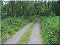
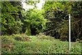
Clifton Heath
Footpath off Oxford Road into Clifton Heath
Image: © Shaun Ferguson
Taken: 28 Jun 2009
0.04 miles
2
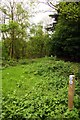
Bridleway through the nettles to Oxford Road
Image: © Steve Daniels
Taken: 26 Apr 2011
0.16 miles
3
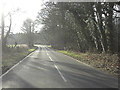
B4015 southwest of Golden Balls roundabout
One counts oneself lucky to have been around it!
Image: © Stuart Logan
Taken: 4 Feb 2012
0.17 miles
10
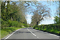
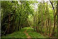
B4015 Oxford Road
Towards Chiselhampton from Clifton Hampden.
Image: © Robin Webster
Taken: 25 Apr 2021
0.22 miles