IMAGES TAKEN NEAR TO
Hillsborough Close, OXFORD, OX4 3SN
Introduction
This page details the photographs taken nearby to Hillsborough Close, OX4 3SN by members of the Geograph project.
The Geograph project started in 2005 with the aim of publishing, organising and preserving representative images for every square kilometre of Great Britain, Ireland and the Isle of Man.

There are currently over 7.5m images from over14,400 individuals and you can help contribute to the project by visiting https://www.geograph.org.uk
Image Map
Images are licensed for reuse under creativecommons.org/licenses/by-sa/2.0
Notes
- Clicking on the map will re-center to the selected point.
- The higher the marker number, the further away the image location is from the centre of the postcode.
Image Listing (24 Images Found)
Images are licensed for reuse under creativecommons.org/licenses/by-sa/2.0
Image
Details
Distance
1
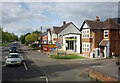
Houses and Garage, Rose Hill
This end of the A4158 is Rose Hill. It has two other names before it gets to the city centre.
Buzy Beez garage has cones across the forecourt and an agents board outside so may not look like this much longer.
Image: © Des Blenkinsopp
Taken: 21 Apr 2024
0.06 miles
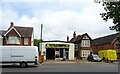
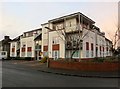
3

The Co-op on Rose Hill
The Co-op was built on the site of the Prince of Prussia pub. The pub was formerly known as the Ox and before that, the Allied Arms. It was a former Morrells pub.
Image: © Steve Daniels
Taken: 17 Oct 2013
0.09 miles
4
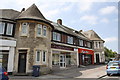
Shops on Courtland Road from Rose Hill
Image: © Roger Templeman
Taken: 4 Jun 2011
0.15 miles
6

Oxford Road at the junction of the Ring Road
Image: © David Howard
Taken: 21 Feb 2016
0.15 miles
7
Queens Court on Kelburne Road
Queens Court is built on the site of the former public house, The Queens.
Image: © Steve Daniels
Taken: 2 Feb 2017
0.15 miles
8
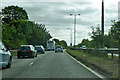
A4142 Eastern Bypass Road
Going anticlockwise around Oxford.
Image: © Robin Webster
Taken: 11 Aug 2019
0.16 miles
9
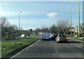
A4142 junction with A4158
This 3 way junction is controlled by traffic lights and a roundabout.
Image: © Stuart Logan
Taken: 4 Feb 2012
0.16 miles
10
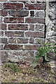
Benchmark on Cowley Road wall at junction with Long Lane
Ordnance Survey cut mark benchmark described on the Bench Mark Database at http://www.bench-marks.org.uk/bm32518
Image: © Roger Templeman
Taken: 4 Jun 2011
0.16 miles