IMAGES TAKEN NEAR TO
Rahere Road, OXFORD, OX4 3QG
Introduction
This page details the photographs taken nearby to Rahere Road, OX4 3QG by members of the Geograph project.
The Geograph project started in 2005 with the aim of publishing, organising and preserving representative images for every square kilometre of Great Britain, Ireland and the Isle of Man.

There are currently over 7.5m images from over14,400 individuals and you can help contribute to the project by visiting https://www.geograph.org.uk
Image Map
Images are licensed for reuse under creativecommons.org/licenses/by-sa/2.0
Notes
- Clicking on the map will re-center to the selected point.
- The higher the marker number, the further away the image location is from the centre of the postcode.
Image Listing (13 Images Found)
Images are licensed for reuse under creativecommons.org/licenses/by-sa/2.0
Image
Details
Distance
1

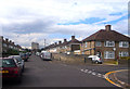
Church Cowley St James Primary School in Bartholomew Road
Image: © Steve Daniels
Taken: 27 Sep 2009
0.07 miles
2
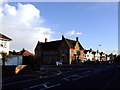
Nuffield Arms, Cowley
Still in Halls Brewery livery - closed early 1980s?
Image: © al partington
Taken: 28 Feb 2006
0.08 miles
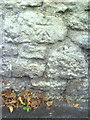
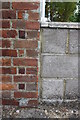
4
Benchmark on #139 Cowley Road
Ordnance Survey cut mark benchmark described on the Bench Mark Database at http://www.bench-marks.org.uk/bm38219
Image: © Roger Templeman
Taken: 4 Jun 2011
0.13 miles
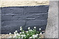
5
Benchmark on wall of Littlemore Road outside St James Place
Ordnance Survey cut mark benchmark described on the Bench Mark Database at http://www.bench-marks.org.uk/bm35749
Image: © Roger Templeman
Taken: 14 Oct 2010
0.17 miles
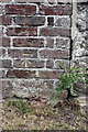
6
Benchmark on side of garage attached to #22 Kelburne Road
Ordnance Survey cut mark benchmark described on the Bench Mark Database at http://www.bench-marks.org.uk/bm38194
Image: © Roger Templeman
Taken: 4 Jun 2011
0.19 miles
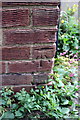
7
Benchmark on Cowley Road wall at junction with Long Lane
Ordnance Survey cut mark benchmark described on the Bench Mark Database at http://www.bench-marks.org.uk/bm32518
Image: © Roger Templeman
Taken: 4 Jun 2011
0.21 miles
9
Benchmark on #63 Long Lane
Ordnance Survey cut mark benchmark described on the Bench Mark Database at http://www.bench-marks.org.uk/bm38220
Image: © Roger Templeman
Taken: 4 Jun 2011
0.22 miles
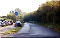
10
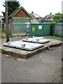
Pumping Station and Electricity sub station
Image: © Alex McGregor
Taken: 14 Aug 2013
0.22 miles