IMAGES TAKEN NEAR TO
Crowell Road, OXFORD, OX4 3LN
Introduction
This page details the photographs taken nearby to Crowell Road, OX4 3LN by members of the Geograph project.
The Geograph project started in 2005 with the aim of publishing, organising and preserving representative images for every square kilometre of Great Britain, Ireland and the Isle of Man.

There are currently over 7.5m images from over14,400 individuals and you can help contribute to the project by visiting https://www.geograph.org.uk
Image Map
Images are licensed for reuse under creativecommons.org/licenses/by-sa/2.0
Notes
- Clicking on the map will re-center to the selected point.
- The higher the marker number, the further away the image location is from the centre of the postcode.
Image Listing (43 Images Found)
Images are licensed for reuse under creativecommons.org/licenses/by-sa/2.0
Image
Details
Distance
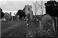
2
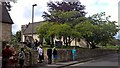
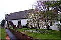
St James' parish church, Cowley
On Beauchamp Lane
Image: © Chris Morgan
Taken: 20 May 2017
0.05 miles
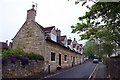
4
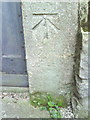
Benchmark on Cowley Church
Ordnance Survey cut mark benchmark described on the Bench Mark Database at http://www.bench-marks.org.uk/bm19899
Image: © Roger Templeman
Taken: 14 Oct 2010
0.06 miles
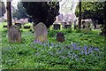
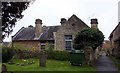
7
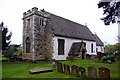
St James The Apostle church in Cowley
Image: © Steve Daniels
Taken: 16 Apr 2009
0.07 miles