IMAGES TAKEN NEAR TO
Kames Close, OXFORD, OX4 3LD
Introduction
This page details the photographs taken nearby to Kames Close, OX4 3LD by members of the Geograph project.
The Geograph project started in 2005 with the aim of publishing, organising and preserving representative images for every square kilometre of Great Britain, Ireland and the Isle of Man.

There are currently over 7.5m images from over14,400 individuals and you can help contribute to the project by visiting https://www.geograph.org.uk
Image Map
Images are licensed for reuse under creativecommons.org/licenses/by-sa/2.0
Notes
- Clicking on the map will re-center to the selected point.
- The higher the marker number, the further away the image location is from the centre of the postcode.
Image Listing (32 Images Found)
Images are licensed for reuse under creativecommons.org/licenses/by-sa/2.0
Image
Details
Distance
1
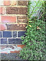
Benchmark on #44 Littlehay Road
Ordnance Survey cut mark benchmark described on the Bench Mark Database at http://www.bench-marks.org.uk/bm35730
Image: © Roger Templeman
Taken: 14 Oct 2010
0.06 miles
2
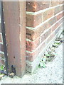
Benchmark on #4 Cornwallis Road
Ordnance Survey cut mark benchmark described on the Bench Mark Database at http://www.bench-marks.org.uk/bm35731
Image: © Roger Templeman
Taken: 14 Oct 2010
0.07 miles
3
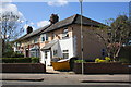
Row of houses on Rymers Lane
The nearest house is #39
Image: © Roger Templeman
Taken: 10 Apr 2014
0.08 miles
6
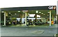
Former Q8 service station, Oxford Road, Cowley
Since demolished and replaced by BP
Image: © Roger Cornfoot
Taken: 31 May 1991
0.15 miles
8

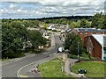
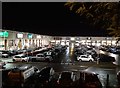
Templars Shopping Park
Out of town shopping in the centre of Cowley.
Image: © Bill Boaden
Taken: 4 Jul 2020
0.16 miles
10
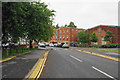
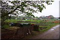
Rymers Lane
The road is mostly residential. The surviving facade to the right bears an inscription: "The Oxfordshire Steam Ploughing Company, Engineers".
Image: © Bill Boaden
Taken: 4 Jul 2020
0.17 miles