IMAGES TAKEN NEAR TO
Cricket Road, OXFORD, OX4 3DR
Introduction
This page details the photographs taken nearby to Cricket Road, OX4 3DR by members of the Geograph project.
The Geograph project started in 2005 with the aim of publishing, organising and preserving representative images for every square kilometre of Great Britain, Ireland and the Isle of Man.

There are currently over 7.5m images from over14,400 individuals and you can help contribute to the project by visiting https://www.geograph.org.uk
Image Map
Images are licensed for reuse under creativecommons.org/licenses/by-sa/2.0
Notes
- Clicking on the map will re-center to the selected point.
- The higher the marker number, the further away the image location is from the centre of the postcode.
Image Listing (23 Images Found)
Images are licensed for reuse under creativecommons.org/licenses/by-sa/2.0
Image
Details
Distance
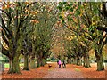
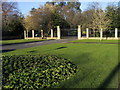
3
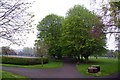
Avenue of horse chestnut trees in Florence Park
Image: © Steve Daniels
Taken: 16 Apr 2009
0.10 miles
4
Avenue of horse chestnut trees in Florence Park
Florence Park was opened in 1934.
Image: © Steve Daniels
Taken: 4 Nov 2015
0.12 miles
6
Cricket Road entrance to Florence Park
Image: © Steve Daniels
Taken: 16 Apr 2009
0.12 miles
7
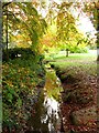
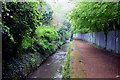
Drainage ditch in Florence Park
Florence Park was opened in 1934.
Image: © Steve Daniels
Taken: 4 Nov 2015
0.13 miles
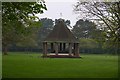
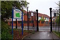
8
Pedestrian entrance to Florence Park
Off Cornwallis Road the pedestrian entrance to Florence Park
Image: © Shaun Ferguson
Taken: 7 Dec 2008
0.13 miles
9
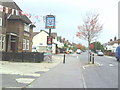
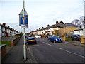
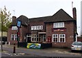
Shelley Arms at the cross roads
Straight ahead is Cricket Road, right is Shelley Road
Image: © Roger Templeman
Taken: 14 Oct 2010
0.14 miles