IMAGES TAKEN NEAR TO
Pony Road, OXFORD, OX4 2SE
Introduction
This page details the photographs taken nearby to Pony Road, OX4 2SE by members of the Geograph project.
The Geograph project started in 2005 with the aim of publishing, organising and preserving representative images for every square kilometre of Great Britain, Ireland and the Isle of Man.

There are currently over 7.5m images from over14,400 individuals and you can help contribute to the project by visiting https://www.geograph.org.uk
Image Map
Images are licensed for reuse under creativecommons.org/licenses/by-sa/2.0
Notes
- Clicking on the map will re-center to the selected point.
- The higher the marker number, the further away the image location is from the centre of the postcode.
Image Listing (36 Images Found)
Images are licensed for reuse under creativecommons.org/licenses/by-sa/2.0
Image
Details
Distance
1
Light industry and offices, Cowley
On the road to Horspath, just off the Oxford Eastern Bypass.
Image: © David Hawgood
Taken: 30 Jan 2007
0.09 miles
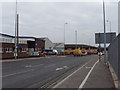
2

Eastern Bypass Road
Eastern Bypass Road heading to the junction with Horspath Road
Image: © Shaun Ferguson
Taken: 14 Dec 2008
0.09 miles

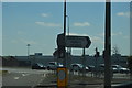
4

A4142 Eastern Bypass Road
Going anticlockwise around Oxford.
Image: © Robin Webster
Taken: 11 Aug 2019
0.11 miles


8
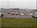
Car park of motor works, Cowley
View from Horspath road of BMW Mini works car park.
Image: © David Hawgood
Taken: 30 Jan 2007
0.13 miles
9
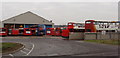
Bus depot at Cowley
Buses at this Stagecoach depot include ones for a frequent service from Oxford to London.
Image: © David Hawgood
Taken: 30 Jan 2007
0.14 miles