IMAGES TAKEN NEAR TO
Hollow Way, OXFORD, OX4 2PR
Introduction
This page details the photographs taken nearby to Hollow Way, OX4 2PR by members of the Geograph project.
The Geograph project started in 2005 with the aim of publishing, organising and preserving representative images for every square kilometre of Great Britain, Ireland and the Isle of Man.

There are currently over 7.5m images from over14,400 individuals and you can help contribute to the project by visiting https://www.geograph.org.uk
Image Map
Images are licensed for reuse under creativecommons.org/licenses/by-sa/2.0
Notes
- Clicking on the map will re-center to the selected point.
- The higher the marker number, the further away the image location is from the centre of the postcode.
Image Listing (18 Images Found)
Images are licensed for reuse under creativecommons.org/licenses/by-sa/2.0
Image
Details
Distance
1

Driving Test Centre, Cowley
Situated in James Wolfe Road OX4 2PY, this driving test centre carries out practical driving tests only for cars and taxis. The DSA notice on the building says "Please do not enter car park until 5 minutes before your test". Motor cycle tests are carried out instead at the Kassam Stadium in Grenoble Road where Oxford United and London Welsh play their football and rugby matches respectively, SP5402 refers.
Image: © David Hillas
Taken: 9 Jun 2015
0.06 miles
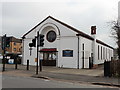
2
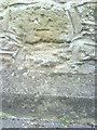
Benchmark on #169 Hollow Way
Ordnance Survey cut mark benchmark described on the Bench Mark Database at http://www.bench-marks.org.uk/bm35750
Image: © Roger Templeman
Taken: 14 Oct 2010
0.16 miles
3
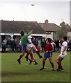
Morris Motors Sports Ground
This has now disappeared under a housing development. During the 1970s and 1980s The Holloway ground boasted the best pitches in Oxfordshire.
Image: © Steve Daniels
Taken: 4 May 1981
0.16 miles
4
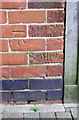
Benchmark on #4 Horspath Road
Ordnance Survey cut mark benchmark described on the Bench Mark Database at http://www.bench-marks.org.uk/bm47162
Image: © Roger Templeman
Taken: 8 Feb 2013
0.16 miles
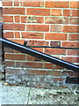
5
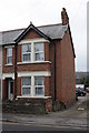
#169 Hollow Way
There is an OS benchmark Image on the side of the house near the front corner
Image: © Roger Templeman
Taken: 8 Feb 2013
0.16 miles
6

#4 Horspath Road
There is an OS benchmark Image on the side of the house at the far end of the wooden fence above the access drive to the rears of #4 and #6. Holes in the pavement have been outlined in white awaiting repair.
Image: © Roger Templeman
Taken: 8 Feb 2013
0.17 miles
7
Benchmark on wall of Barracks Lane
Inverted Ordnance Survey cut mark benchmark described on the Bench Mark Database at http://www.bench-marks.org.uk/bm35753
Image: © Roger Templeman
Taken: 14 Oct 2010
0.19 miles
8
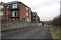
Barracks Lane
There is an inverted OS benchmark Image on a stone in the wall about 1m nearer than the lamp post
Image: © Roger Templeman
Taken: 8 Feb 2013
0.21 miles
9
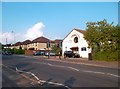
Hollow Way, Cowley
The church is dedicated to St Francis.
Image: © Des Blenkinsopp
Taken: 29 May 2012
0.21 miles