IMAGES TAKEN NEAR TO
White Road, OXFORD, OX4 2JL
Introduction
This page details the photographs taken nearby to White Road, OX4 2JL by members of the Geograph project.
The Geograph project started in 2005 with the aim of publishing, organising and preserving representative images for every square kilometre of Great Britain, Ireland and the Isle of Man.

There are currently over 7.5m images from over14,400 individuals and you can help contribute to the project by visiting https://www.geograph.org.uk
Image Map
Images are licensed for reuse under creativecommons.org/licenses/by-sa/2.0
Notes
- Clicking on the map will re-center to the selected point.
- The higher the marker number, the further away the image location is from the centre of the postcode.
Image Listing (22 Images Found)
Images are licensed for reuse under creativecommons.org/licenses/by-sa/2.0
Image
Details
Distance
1
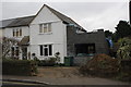
#50 White Road
House at junction of White Road and Marshall Road
Image: © Roger Templeman
Taken: 8 Feb 2013
0.02 miles
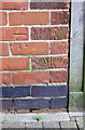
2
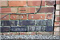
Benchmark on #20 Oliver Road
Ordnance Survey cut mark benchmark described on the Bench Mark Database at http://www.bench-marks.org.uk/bm47161
Image: © Roger Templeman
Taken: 8 Feb 2013
0.06 miles
3

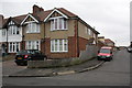
Houses on Oliver Road
There is an OS benchmark Image on the left hand side house above its side access drive and near its front corner.
Image: © Roger Templeman
Taken: 8 Feb 2013
0.06 miles
4
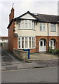
#57 Oliver Road
There is an OS benchmark Image on the side of the house by the metal gate across the drive
Image: © Roger Templeman
Taken: 8 Feb 2013
0.14 miles
5
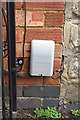
Benchmark on #57 Oliver Road
The Ordnance Survey cut mark benchmark which is partly hidded behind a Virgin Media box, is described on the Bench Mark Database at http://www.bench-marks.org.uk/bm47164
Image: © Roger Templeman
Taken: 8 Feb 2013
0.14 miles
6

Fern Hill Road, Cowley
A residential street leading to the eastern by-pass and the BMW motor works just visible at the end of the street.
Image: © Des Blenkinsopp
Taken: 30 Nov 2011
0.16 miles
7

#4 Horspath Road
There is an OS benchmark Image on the side of the house at the far end of the wooden fence above the access drive to the rears of #4 and #6. Holes in the pavement have been outlined in white awaiting repair.
Image: © Roger Templeman
Taken: 8 Feb 2013
0.17 miles
8
Benchmark on #4 Horspath Road
Ordnance Survey cut mark benchmark described on the Bench Mark Database at http://www.bench-marks.org.uk/bm47162
Image: © Roger Templeman
Taken: 8 Feb 2013
0.17 miles
9
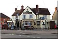
The Prince of Wales on Horspath Road
The Prince of Wales is a former Morrells pub.
Image: © Steve Daniels
Taken: 15 Aug 2013
0.18 miles