IMAGES TAKEN NEAR TO
Alec Issigonis Way, OXFORD, OX4 2HU
Introduction
This page details the photographs taken nearby to Alec Issigonis Way, OX4 2HU by members of the Geograph project.
The Geograph project started in 2005 with the aim of publishing, organising and preserving representative images for every square kilometre of Great Britain, Ireland and the Isle of Man.

There are currently over 7.5m images from over14,400 individuals and you can help contribute to the project by visiting https://www.geograph.org.uk
Image Map
Images are licensed for reuse under creativecommons.org/licenses/by-sa/2.0
Notes
- Clicking on the map will re-center to the selected point.
- The higher the marker number, the further away the image location is from the centre of the postcode.
Image Listing (34 Images Found)
Images are licensed for reuse under creativecommons.org/licenses/by-sa/2.0
Image
Details
Distance
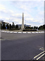
1

Water Feature, Oxford Business Park
The Oxford Business Park is a business park of 88 acres (360,000 m2) at Cowley on the eastern edge of Oxford, England. The park is immediately adjacent to the Oxford Ring Road.
The park was developed on the site of Oxford Military College 1876-1896, later the original Morris Motors factory, sold in 1992 by British Leyland to the property group Arlington Securities. Arlington was itself sold to the Australian property company Macquarie Goodman, now the Goodman Group, in 2005.
Major tenants include Wiley-Blackwell, Harley-Davidson, Oxfam, Royal Mail and HM Revenue and Customs. There is also an hotel on the site.
Image: © Des Blenkinsopp
Taken: 28 May 2012
0.07 miles
2

Abandoned office building, Oxford Business Park
Weeds growing up in the car park and no sign of activity. What does this building do?
Image: © Pierre Marshall
Taken: 19 Mar 2021
0.09 miles
3
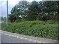
Trees on verge in front of Oxford Business Park
Image: © David Howard
Taken: 29 Jun 2011
0.12 miles
4

Houses on Oliver Road
There is an OS benchmark Image on the left hand side house above its side access drive and near its front corner.
Image: © Roger Templeman
Taken: 8 Feb 2013
0.12 miles
5
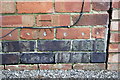
Benchmark on #20 Oliver Road
Ordnance Survey cut mark benchmark described on the Bench Mark Database at http://www.bench-marks.org.uk/bm47161
Image: © Roger Templeman
Taken: 8 Feb 2013
0.12 miles
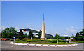
6
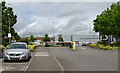
Traffic Island Oxford Business Park
The junction of Garsington Road with John Smith Drive.
Image: © David Dixon
Taken: 8 Aug 2010
0.13 miles
8

Study of a Gasoline Station
Shell, Cowley.
The title of the photograph is a tribute to the 1963 Ed Ruscha publication 'Twentysix Gasoline Stations'.
Image: © David Bremner
Taken: 6 Jun 2024
0.14 miles
9
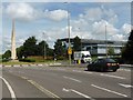
Roundabout on Garsington Road, Oxford
Image: © David Gearing
Taken: 21 Jul 2016
0.14 miles