IMAGES TAKEN NEAR TO
Temple Road, OXFORD, OX4 2ET
Introduction
This page details the photographs taken nearby to Temple Road, OX4 2ET by members of the Geograph project.
The Geograph project started in 2005 with the aim of publishing, organising and preserving representative images for every square kilometre of Great Britain, Ireland and the Isle of Man.

There are currently over 7.5m images from over14,400 individuals and you can help contribute to the project by visiting https://www.geograph.org.uk
Image Map
Images are licensed for reuse under creativecommons.org/licenses/by-sa/2.0
Notes
- Clicking on the map will re-center to the selected point.
- The higher the marker number, the further away the image location is from the centre of the postcode.
Image Listing (33 Images Found)
Images are licensed for reuse under creativecommons.org/licenses/by-sa/2.0
Image
Details
Distance
1
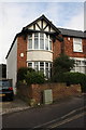
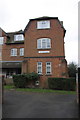
#63 Crescent Road
There is an OS benchmark Image on the white-painted bricks on the side of the house
Image: © Roger Templeman
Taken: 8 Feb 2013
0.10 miles
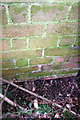
2
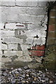
Benchmark on #63 Crescent Road
Ordnance Survey cut mark benchmark described on the Bench Mark Database at http://www.bench-marks.org.uk/bm35754
Image: © Roger Templeman
Taken: 8 Feb 2013
0.10 miles
3
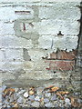
Benchmark on #63 Crescent Road
Ordnance Survey cut mark benchmark described on the Bench Mark Database at http://www.bench-marks.org.uk/bm35754
Image: © Roger Templeman
Taken: 14 Oct 2010
0.10 miles
4
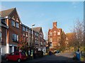
Don Bosco Close
A new development in Temple Cowley.
Don Bosco, aka St. John Bosco,http://en.wikipedia.org/wiki/Saint_John_Bosco was the founder of the Salesians, the Catholic educational organisation who established the school in Salesian House, the building in the background.
Image: © Des Blenkinsopp
Taken: 30 Nov 2011
0.14 miles
5
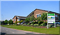
Oxford Business Park
The park was developed on the site of Oxford Military College 1876-1896, later the original Morris Motors factory, sold in 1992 by British Leyland.
These buildings are on Alec Issigonis Way, named after the designer of the Mini, which is still built in Oxford.
Image: © Des Blenkinsopp
Taken: 28 May 2012
0.15 miles
6
NW end of Salesian House, Crescent Road
There is an OS benchmark Image on the left face of the buttress on the front left hand side of front block of the apartment block
Image: © Roger Templeman
Taken: 8 Feb 2013
0.17 miles
7
Benchmark on buttress of Salesian House
The Ordnance Survey cut mark benchmark, which is low down on the buttress and behind a hedge bush, is described on the Bench Mark Database at http://www.bench-marks.org.uk/bm47139
Image: © Roger Templeman
Taken: 8 Feb 2013
0.17 miles
8
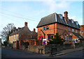
St Josephs Hall
The sign outside says Kings College, so I'm guessing this is student accommodation.
Image: © Des Blenkinsopp
Taken: 30 Nov 2011
0.17 miles
9
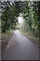
Cycle Path, Cowley Marsh
There is an OS benchmark Image on the stone on the left hand side of the track
Image: © Roger Templeman
Taken: 8 Feb 2013
0.18 miles
10
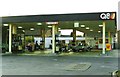
Former Q8 service station, Oxford Road, Cowley
Since demolished and replaced by BP
Image: © Roger Cornfoot
Taken: 31 May 1991
0.18 miles