IMAGES TAKEN NEAR TO
Oxford Road, OXFORD, OX4 2ER
Introduction
This page details the photographs taken nearby to Oxford Road, OX4 2ER by members of the Geograph project.
The Geograph project started in 2005 with the aim of publishing, organising and preserving representative images for every square kilometre of Great Britain, Ireland and the Isle of Man.

There are currently over 7.5m images from over14,400 individuals and you can help contribute to the project by visiting https://www.geograph.org.uk
Image Map
Images are licensed for reuse under creativecommons.org/licenses/by-sa/2.0
Notes
- Clicking on the map will re-center to the selected point.
- The higher the marker number, the further away the image location is from the centre of the postcode.
Image Listing (45 Images Found)
Images are licensed for reuse under creativecommons.org/licenses/by-sa/2.0
Image
Details
Distance
1
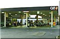
Former Q8 service station, Oxford Road, Cowley
Since demolished and replaced by BP
Image: © Roger Cornfoot
Taken: 31 May 1991
0.08 miles
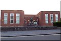
4
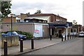
Temple Cowley Pools and Fitness Centre
Oxford City Council plan to close and demolish the pool when they have constructed a new one in Blackbird Leys.
Image: © Steve Daniels
Taken: 15 Aug 2013
0.16 miles
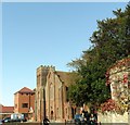
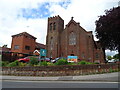
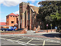
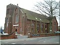
10
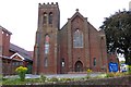
The United Reformed Church on Oxford Road
Image: © Steve Daniels
Taken: 15 Aug 2013
0.18 miles