IMAGES TAKEN NEAR TO
John Smith Drive, OX4 2EQ
Introduction
This page details the photographs taken nearby to John Smith Drive, OX4 2EQ by members of the Geograph project.
The Geograph project started in 2005 with the aim of publishing, organising and preserving representative images for every square kilometre of Great Britain, Ireland and the Isle of Man.

There are currently over 7.5m images from over14,400 individuals and you can help contribute to the project by visiting https://www.geograph.org.uk
Image Map
Images are licensed for reuse under creativecommons.org/licenses/by-sa/2.0
Notes
- Clicking on the map will re-center to the selected point.
- The higher the marker number, the further away the image location is from the centre of the postcode.
Image Listing (39 Images Found)
Images are licensed for reuse under creativecommons.org/licenses/by-sa/2.0
Image
Details
Distance


3
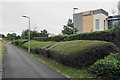
Sculpted hedges on Oxford Business Park
Part of the frontage of the British Gas local headquarters.
Image: © Bill Boaden
Taken: 4 Jul 2020
0.12 miles
4
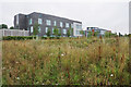
Office blocks in Oxford Business Park
A further block has been built on the end of the row but it is not yet shown on most maps.
Image: © Bill Boaden
Taken: 4 Jul 2020
0.13 miles
5
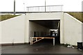
Subway under the Eastern By-Pass
The subway leads to Tesco and the Cowley Retail Park.
Image: © Steve Daniels
Taken: 18 Oct 2014
0.14 miles
6

Vacant land at Oxford Business Park
This land is not open to the public, but I don't know whether it is earmarked for more development.
Image: © Bill Boaden
Taken: 4 Jul 2020
0.14 miles
7
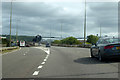
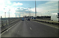
A4142 Eastern Bypass Road
Going anticlockwise around Oxford. The B480 Cowley exit is on the left.
Image: © Robin Webster
Taken: 11 Aug 2019
0.14 miles
8
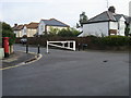
Bailey Road
Bailey Road at barriered junction with Phipps Road
Image: © Shaun Ferguson
Taken: 14 Dec 2008
0.16 miles
9
Garsington Road at the junction of the Ring Road
Image: © David Howard
Taken: 21 Feb 2016
0.16 miles
10
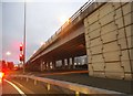
A4142 Eastern Bypass
This elevated section of the Oxford Ring Road is passing over the Garsington Road. In the distance Didcot power station cooling towers create a little localised strato-cumulus.
Image: © Stuart Logan
Taken: 4 Feb 2012
0.17 miles