IMAGES TAKEN NEAR TO
William Morris Close, OX4 2DE
Introduction
This page details the photographs taken nearby to William Morris Close, OX4 2DE by members of the Geograph project.
The Geograph project started in 2005 with the aim of publishing, organising and preserving representative images for every square kilometre of Great Britain, Ireland and the Isle of Man.

There are currently over 7.5m images from over14,400 individuals and you can help contribute to the project by visiting https://www.geograph.org.uk
Image Map
Images are licensed for reuse under creativecommons.org/licenses/by-sa/2.0
Notes
- Clicking on the map will re-center to the selected point.
- The higher the marker number, the further away the image location is from the centre of the postcode.
Image Listing (23 Images Found)
Images are licensed for reuse under creativecommons.org/licenses/by-sa/2.0
Image
Details
Distance
1
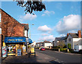
Smith & Low
Electrical and DIY corner shop on Hollow Way.
Image: © Des Blenkinsopp
Taken: 30 Nov 2011
0.07 miles
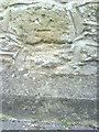
2
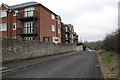
Barracks Lane
There is an inverted OS benchmark Image on a stone in the wall about 1m nearer than the lamp post
Image: © Roger Templeman
Taken: 8 Feb 2013
0.08 miles
3
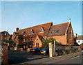
Temple Cloisters, Cowley
This unusual street name can just be made out on the sign by the gate post. This area of Cowley is known as Temple Cowley after a foundation made by Margaret of Boulogne in 1139 for the Knights Templar. http://en.wikipedia.org/wiki/Knights_Templar
Shown here is the chapel of the Salesian school http://archive.catholicherald.co.uk/article/18th-june-1948/7/cowley-salesian-school-started-by-an-accident
The Salesians are a Catholic organisation focusing on education. http://en.wikipedia.org/wiki/Salesians_of_Don_Bosco
Image: © Des Blenkinsopp
Taken: 30 Nov 2011
0.08 miles
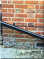
4
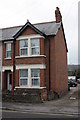
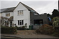
#169 Hollow Way
There is an OS benchmark Image on the side of the house near the front corner
Image: © Roger Templeman
Taken: 8 Feb 2013
0.08 miles
5
Benchmark on wall of Barracks Lane
Inverted Ordnance Survey cut mark benchmark described on the Bench Mark Database at http://www.bench-marks.org.uk/bm35753
Image: © Roger Templeman
Taken: 14 Oct 2010
0.09 miles
6
Benchmark on #169 Hollow Way
Ordnance Survey cut mark benchmark described on the Bench Mark Database at http://www.bench-marks.org.uk/bm35750
Image: © Roger Templeman
Taken: 14 Oct 2010
0.09 miles
7
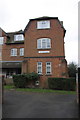
NW end of Salesian House, Crescent Road
There is an OS benchmark Image on the left face of the buttress on the front left hand side of front block of the apartment block
Image: © Roger Templeman
Taken: 8 Feb 2013
0.09 miles
8
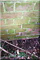
Benchmark on buttress of Salesian House
The Ordnance Survey cut mark benchmark, which is low down on the buttress and behind a hedge bush, is described on the Bench Mark Database at http://www.bench-marks.org.uk/bm47139
Image: © Roger Templeman
Taken: 8 Feb 2013
0.09 miles
10

Hollow Way, Cowley
Watch out for Giant Allotments.
Image: © Des Blenkinsopp
Taken: 30 Nov 2011
0.13 miles