IMAGES TAKEN NEAR TO
Meadow Lane, OXFORD, OX4 1TL
Introduction
This page details the photographs taken nearby to Meadow Lane, OX4 1TL by members of the Geograph project.
The Geograph project started in 2005 with the aim of publishing, organising and preserving representative images for every square kilometre of Great Britain, Ireland and the Isle of Man.

There are currently over 7.5m images from over14,400 individuals and you can help contribute to the project by visiting https://www.geograph.org.uk
Image Map
Images are licensed for reuse under creativecommons.org/licenses/by-sa/2.0
Notes
- Clicking on the map will re-center to the selected point.
- The higher the marker number, the further away the image location is from the centre of the postcode.
Image Listing (48 Images Found)
Images are licensed for reuse under creativecommons.org/licenses/by-sa/2.0
Image
Details
Distance
1
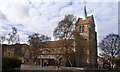
Greyfriars Church, Iffley Road, Oxford
This distinctive flintwork church was built in 1931 and is attached to a centre for Franciscan studies.
http://www.greyfriarsoxford.org.uk/friary.htm
Image: © Des Blenkinsopp
Taken: 3 Apr 2012
0.08 miles
2
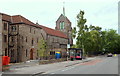
Iffley Road, Oxford
Greyfriars Friary and parish church is seen here from Aston Street. It is run by the Order of Friars Minor Capuchin, a Franciscan Order. It is the only flint-stone Norman-style building in the city and it has this distinctive green spire. Behind the trees ahead are the premises of the University of Oxford Rugby Football Club. Magdalen Bridge in the city centre is 10 minutes walk away, to the right.
Image: © David Hallam-Jones
Taken: 30 Jul 2013
0.08 miles
3
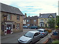
The Chester Arms
Local pub catering for families and offering live music; at the foot of Chester Street off the Iffley Road.
Image: © Natasha Ceridwen de Chroustchoff
Taken: 6 Mar 2008
0.09 miles
4
Oxford, Iffley Fields: Chester Street
Image: © Christopher Hilton
Taken: 23 Jun 2009
0.09 miles
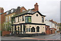
5
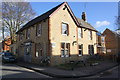
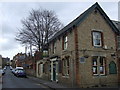
'The Chester' at the Argyle Street / Chester Street junction
There is an OS benchamrk Image on the near corner, left hand face, of the pub, behind the rear wheel of the bicycle
Image: © Roger Templeman
Taken: 30 Jan 2016
0.10 miles
6
Iffley Road Vicinity, Oxford
When Alfred Thomas, a part-time bookbinder and part-time victualler, ran this pub in 1901 it was known as The Chester Arms Tavern. It is not functioning at present although there are moves afoot to try to prevent it from being sold off and converted into residential units. This is the south-west end of Chester Street where it joins Argyle Street. Beyond the skip is a footpath that links up with Iffley Fields within seconds. Iffley Fields is a 'green area' that boasts a small grassed area and a children's playground.
Image: © David Hallam-Jones
Taken: 30 Jul 2013
0.10 miles
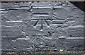
7
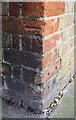
Benchmark on 'The Chester'
Ordnance Survey cut mark benchmark described on the Bench Mark Database at http://www.bench-marks.org.uk/bm28697
Image: © Roger Templeman
Taken: 30 Jan 2016
0.10 miles
8
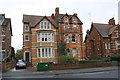
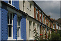
Houses on Iffley Road
There is an OS benchmark Image on the wall pier in the middle of the image
Image: © Roger Templeman
Taken: 24 Feb 2014
0.10 miles
9
Fir Tree public house at Iffley Road / Bullingdon Road junction
There is an OS benchmark Image on the near corner, front face of the pub, behind the table
Image: © Roger Templeman
Taken: 24 Feb 2014
0.11 miles
10
Benchmark on the Fir Tree pub, Iffley Road
Ordnance Survey cut mark benchmark described on the Bench Mark Database at http://www.bench-marks.org.uk/bm29480
Image: © Roger Templeman
Taken: 24 Feb 2014
0.11 miles