IMAGES TAKEN NEAR TO
Denmark Street, OXFORD, OX4 1QS
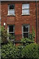
Introduction
This page details the photographs taken nearby to Denmark Street, OX4 1QS by members of the Geograph project.
The Geograph project started in 2005 with the aim of publishing, organising and preserving representative images for every square kilometre of Great Britain, Ireland and the Isle of Man.

There are currently over 7.5m images from over14,400 individuals and you can help contribute to the project by visiting https://www.geograph.org.uk
Image Map
Images are licensed for reuse under creativecommons.org/licenses/by-sa/2.0
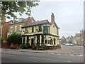
Notes
- Clicking on the map will re-center to the selected point.
- The higher the marker number, the further away the image location is from the centre of the postcode.
Image Listing (137 Images Found)
Images are licensed for reuse under creativecommons.org/licenses/by-sa/2.0
Image
Details
Distance
1
How Many Traffic Wardens Does It Take To........
Two wardens in tasteful blue and yellow track down another possible infringement along Bullingdon Road.
Image: © Des Blenkinsopp
Taken: 3 Apr 2012
0.05 miles
2
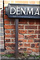
Junction of James Street and Denmark Street
There is an OS benchmark Image under the Denmark Street name sign
Image: © Roger Templeman
Taken: 30 Jan 2016
0.05 miles
3
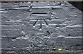
Benchmark on #88 James Street
Ordnance Survey cut mark benchmark described on the Bench Mark Database at http://www.bench-marks.org.uk/bm29518
Image: © Roger Templeman
Taken: 30 Jan 2016
0.05 miles
6
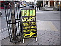
Presidential car wash
On the corner of Jeune Street and Cowley Road.
Cowley Road Methodist church opposite.
Image: © Natasha Ceridwen de Chroustchoff
Taken: 1 Mar 2009
0.06 miles
7
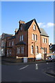
The Queen's College, Cardo Building, Iffley Road /James Street junction
There used to be a boundary stone inscribed 'CJS Mayor 1837' at this corner, see http://www.bench-marks.org.uk/bm19855
Image: © Roger Templeman
Taken: 30 Jan 2016
0.06 miles
8
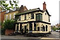
The Fir Tree on Iffley Road
The Fir Tree is a former Morrells pub.
Image: © Steve Daniels
Taken: 11 Oct 2013
0.06 miles
9
Fir Tree
Public house on the corner of Iffley Road and Bullingdon Road.
Image: © Alan Hughes
Taken: 16 Sep 2019
0.06 miles
10
Benchmark on the Fir Tree pub, Iffley Road
Ordnance Survey cut mark benchmark described on the Bench Mark Database at http://www.bench-marks.org.uk/bm29480
Image: © Roger Templeman
Taken: 24 Feb 2014
0.07 miles