IMAGES TAKEN NEAR TO
Bullingdon Road, OXFORD, OX4 1QQ
Introduction
This page details the photographs taken nearby to Bullingdon Road, OX4 1QQ by members of the Geograph project.
The Geograph project started in 2005 with the aim of publishing, organising and preserving representative images for every square kilometre of Great Britain, Ireland and the Isle of Man.

There are currently over 7.5m images from over14,400 individuals and you can help contribute to the project by visiting https://www.geograph.org.uk
Image Map
Images are licensed for reuse under creativecommons.org/licenses/by-sa/2.0
Notes
- Clicking on the map will re-center to the selected point.
- The higher the marker number, the further away the image location is from the centre of the postcode.
Image Listing (184 Images Found)
Images are licensed for reuse under creativecommons.org/licenses/by-sa/2.0
Image
Details
Distance
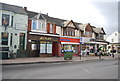
2
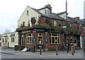
Old pub, new name
This pub on the corner of Bullingdon Road and Cowley Road used to be called The Ampney Cottage. Now it is called after one of the beers produced by its owners, the Oxfordshire brewery that takes its name from Wychwood Forest, as does the posh North Oxford school Image!
Image: © Natasha Ceridwen de Chroustchoff
Taken: 6 Mar 2008
0.04 miles
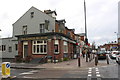
4
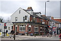
The Black Swan
The Black Swan is on the corner of Crown Street and St Mary's Road. It is a former Morrells pub.
Image: © Steve Daniels
Taken: 11 Oct 2013
0.04 miles
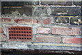
6
Benchmark on side of the Hobgoblin pub
Ordnance Survey cut mark benchmark described on the Bench Mark Database at http://www.bench-marks.org.uk/bm29481.
Image: © Roger Templeman
Taken: 25 Aug 2010
0.05 miles
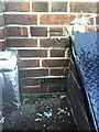
7
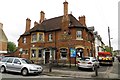
The Cowley Retreat at the Bullingdon Road/Cowley Road junction
There is an OS benchmark Image left of the hatch left of the Bullingdon Road road sign
Image: © Roger Templeman
Taken: 24 Feb 2014
0.05 miles
8
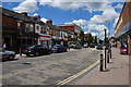
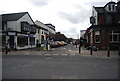
Oxford : Cowley Road
Looking along Cowley Road in the Oxford suburbs.
Image: © Lewis Clarke
Taken: 29 Jun 2014
0.05 miles
9
Benchmark on #105 Bullingdon Road
Ordnance Survey cut mark benchmark described on the Bench Mark Database at http://www.bench-marks.org.uk/bm29519
Image: © Roger Templeman
Taken: 24 Feb 2014
0.05 miles
10

Boarded-up shop at Bullingdon Road / St Mary's Road junction
There is an OS benchmark Image in the bricks left of the former shop's door
Image: © Roger Templeman
Taken: 24 Feb 2014
0.05 miles