IMAGES TAKEN NEAR TO
Southfield Road, OXFORD, OX4 1NY
Introduction
This page details the photographs taken nearby to Southfield Road, OX4 1NY by members of the Geograph project.
The Geograph project started in 2005 with the aim of publishing, organising and preserving representative images for every square kilometre of Great Britain, Ireland and the Isle of Man.

There are currently over 7.5m images from over14,400 individuals and you can help contribute to the project by visiting https://www.geograph.org.uk
Image Map
Images are licensed for reuse under creativecommons.org/licenses/by-sa/2.0
Notes
- Clicking on the map will re-center to the selected point.
- The higher the marker number, the further away the image location is from the centre of the postcode.
Image Listing (89 Images Found)
Images are licensed for reuse under creativecommons.org/licenses/by-sa/2.0
Image
Details
Distance
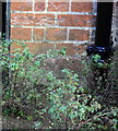
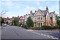
2
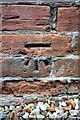
Benchmark on #154 Divinity Road
Ordnance Survey cut mark benchmark described on the Bench Mark Database at http://www.bench-marks.org.uk/bm32579
Image: © Roger Templeman
Taken: 19 Nov 2013
0.04 miles
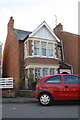
3
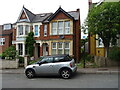
#154 Divinity Road
There is an OS benchmark Image on the side of the house near the corner beyond the wheelie bins
Image: © Roger Templeman
Taken: 19 Nov 2013
0.04 miles
4
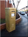
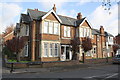
Oxford: postbox № OX4 197, Divinity Road
This postbox is an example of a shortlived square design of the mid-1970s and stands at the junction of Divinity Road (down which we look) and Hill Top Road (left). Royal Mail announced during the London 2012 Games that it would paint a postbox gold in honour of each British Olympic and Paralympic gold medal winner - this one is in honour of Paralympic rowing medallist Lily van den Broecke, who is from these parts.
Image: © Chris Downer
Taken: 7 Dec 2012
0.08 miles
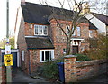
5
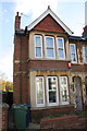
#194 Divinity Road, 'The Beeches'
There is an OS benchmark Image on the corner of the house above the 'Hill Top Road' sign, left of the black downpipe
Image: © Roger Templeman
Taken: 19 Nov 2013
0.09 miles
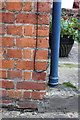
6
Benchmark on #194 Divinity Road
Ordnance Survey cut mark benchmark described on the Bench Mark Database at http://www.bench-marks.org.uk/bm24715
Image: © Roger Templeman
Taken: 19 Nov 2013
0.10 miles
7
Benchmark on #34 Hill Top Road
Ordnance Survey cut mark benchmark described on the Bench Mark Database at http://www.bench-marks.org.uk/bm32580
Image: © Roger Templeman
Taken: 19 Nov 2013
0.10 miles
8
#34 Hill Top Road
There is an OS benchmark Image on the side of the front left corner of the house
Image: © Roger Templeman
Taken: 19 Nov 2013
0.10 miles
10
#104 Divinity Road
There is an OS benchmark Image on the side of the house near the junction with the low brick front side wall
Image: © Roger Templeman
Taken: 19 Nov 2013
0.10 miles