IMAGES TAKEN NEAR TO
Cross Street, OXFORD, OX4 1BZ
Introduction
This page details the photographs taken nearby to Cross Street, OX4 1BZ by members of the Geograph project.
The Geograph project started in 2005 with the aim of publishing, organising and preserving representative images for every square kilometre of Great Britain, Ireland and the Isle of Man.

There are currently over 7.5m images from over14,400 individuals and you can help contribute to the project by visiting https://www.geograph.org.uk
Image Map
Images are licensed for reuse under creativecommons.org/licenses/by-sa/2.0
Notes
- Clicking on the map will re-center to the selected point.
- The higher the marker number, the further away the image location is from the centre of the postcode.
Image Listing (251 Images Found)
Images are licensed for reuse under creativecommons.org/licenses/by-sa/2.0
Image
Details
Distance
1
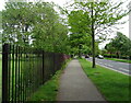
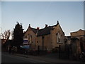
Oxford : Rectory Road
Looking along Rectory Road in the Oxford suburbs.
Image: © Lewis Clarke
Taken: 29 Jun 2014
0.05 miles
2
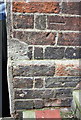
Benchmark on the north face of #48 Rectory Road
Ordnance Survet cut mark benchmark described on the Bench Mark Database at http://www.bench-marks.org.uk/bm24719
Image: © Roger Templeman
Taken: 24 Feb 2014
0.05 miles
3
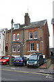
#47 and #48 Rectory Road
There is an OS benchmark Image on the side of the right hand house above step to side path
Image: © Roger Templeman
Taken: 24 Feb 2014
0.05 miles
4
Old Boundary Marker on St Clements Street, Oxford
Parish Boundary Marker by the A420, in parish of Oxford (Oxford District), on the southeast side of the A420 St Clements Street between a lamp post and the front wall of No.78, Citygate. See https://oxfordhistory.org.uk/streets/wayside_stones/boundary/other/stclements.html.
Surveyed
Milestone Society National ID: OX_OXCCOWJ01pb
Image: © D Turner
Taken: 18 Aug 2010
0.07 miles
6
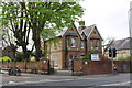
Abbeyfield Care Home, #80 St Clement's Street
There is an OS benchmark Image on the wall pier on the right hand side of the entrance at the junction of St Clement's Street and Rectory Road
Image: © Roger Templeman
Taken: 4 Apr 2014
0.08 miles
7
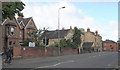
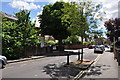
St Clement's Street, Oxford
The A420 Headington to Oxford Road, looking in the direction of The Plains roundabout and the city centre (i.e. the latter being 5 minutes away for a cyclist).
Image: © David Hallam-Jones
Taken: 26 Jul 2013
0.08 miles
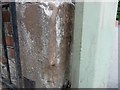
8
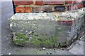
Benchmark beside entrance to #80 St Clement's Street
Ordnance Survey cut mark benchmark described on the Bench Mark Database at http://www.bench-marks.org.uk/bm23443
Image: © Roger Templeman
Taken: 4 Apr 2014
0.08 miles
9
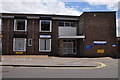
Oxford : The Rectory Centre
An NHS building on Rectory Road in Oxford.
Image: © Lewis Clarke
Taken: 29 Jun 2014
0.08 miles
10
Empty building on St Clement's Street, Oxford
It looks like an ex church but someone there will be able to tell me.
Image: © David Howard
Taken: 13 Mar 2016
0.08 miles