IMAGES TAKEN NEAR TO
Wilson Place, Cave Street, OXFORD, OX4 1AF
Introduction
This page details the photographs taken nearby to Wilson Place, Cave Street, OX4 1AF by members of the Geograph project.
The Geograph project started in 2005 with the aim of publishing, organising and preserving representative images for every square kilometre of Great Britain, Ireland and the Isle of Man.

There are currently over 7.5m images from over14,400 individuals and you can help contribute to the project by visiting https://www.geograph.org.uk
Image Map
Images are licensed for reuse under creativecommons.org/licenses/by-sa/2.0
Notes
- Clicking on the map will re-center to the selected point.
- The higher the marker number, the further away the image location is from the centre of the postcode.
Image Listing (219 Images Found)
Images are licensed for reuse under creativecommons.org/licenses/by-sa/2.0
Image
Details
Distance
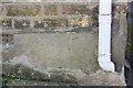
2
Old Boundary Marker on St Clements Street, Oxford
Parish Boundary Marker by the A420, in parish of Oxford (Oxford District), on the southeast side of the A420 St Clements Street between a lamp post and the front wall of No.78, Citygate. See https://oxfordhistory.org.uk/streets/wayside_stones/boundary/other/stclements.html.
Surveyed
Milestone Society National ID: OX_OXCCOWJ01pb
Image: © D Turner
Taken: 18 Aug 2010
0.04 miles
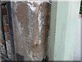
4
Benchmark on #11 Cherwell Street
Ordnance Survey cut mark benchmark described on the Bench Mark Database at http://www.bench-marks.org.uk/bm55958
Image: © Roger Templeman
Taken: 24 Mar 2014
0.05 miles
5
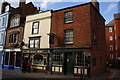
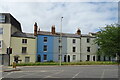
The Half Moon, St Clements Street, Oxford
I'd have tried it if I'd had more time.
Image: © Bill Boaden
Taken: 4 Oct 2009
0.05 miles
7

#11 Cherwell Street at Little Brewery Street junction
There is an OS benchmark Image on the front of the house about 2ft left of the grey downpipe
Image: © Roger Templeman
Taken: 24 Mar 2014
0.06 miles
8
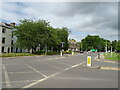
St Clements Street
Looking up St Clements Street from near Marston Road
Image: © Bill Nicholls
Taken: 5 Aug 2016
0.06 miles
9
Harpsichord Place, Oxford
Harpsichord Place is a short street running to the left of the photo. It is off Cherwell Street in the St Clement's area of Oxford.
Image: © David Hawgood
Taken: 4 Jul 2009
0.06 miles
10
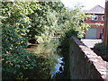
Eastern channel of the River Cherwell, St Clements
The Cherwell splits into three in this area. This branch is between the St Clements area and the Angel and Greyhound Meadow. Photo from an alley from the bottom of Cherwell Street to Bath Street.
Image: © David Hawgood
Taken: 4 Jul 2009
0.06 miles