IMAGES TAKEN NEAR TO
Ash Grove, OXFORD, OX3 9JL
Introduction
This page details the photographs taken nearby to Ash Grove, OX3 9JL by members of the Geograph project.
The Geograph project started in 2005 with the aim of publishing, organising and preserving representative images for every square kilometre of Great Britain, Ireland and the Isle of Man.

There are currently over 7.5m images from over14,400 individuals and you can help contribute to the project by visiting https://www.geograph.org.uk
Image Map
Images are licensed for reuse under creativecommons.org/licenses/by-sa/2.0
Notes
- Clicking on the map will re-center to the selected point.
- The higher the marker number, the further away the image location is from the centre of the postcode.
Image Listing (47 Images Found)
Images are licensed for reuse under creativecommons.org/licenses/by-sa/2.0
Image
Details
Distance
1
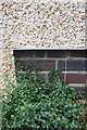
Benchmark below the pebbledash on #23 Ash Grove
Ordnance Survey cut mark benchmark described on the Bench Mark Database at http://www.bench-marks.org.uk/bm51654
Image: © Roger Templeman
Taken: 18 Sep 2013
0.03 miles
2
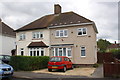
Houses on Ash Grove
There is an OS benchmark Image on bricks below the pebbledash on the side of the right hand side house, on its front corner.
Image: © Roger Templeman
Taken: 18 Sep 2013
0.03 miles
3
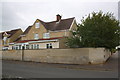
#24A Hawthorn Avenue at Ash Grove junction
Extended and pebbledashed house
Image: © Roger Templeman
Taken: 9 Sep 2015
0.09 miles
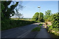
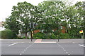
4

Cycle path by the Oxford ring road
The path off Barton Road gives a choice of going under the ring road or else running along this side of it.
Image: © Bill Boaden
Taken: 3 May 2014
0.12 miles
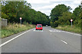
5
Barton Lane, Headington
A quieter lane on the edge of Headington.
Image: © Bill Boaden
Taken: 3 May 2014
0.13 miles
6
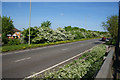
The Oxford ring road
Traversing the eastern side of the city. Spring flowers are in full bloom.
Image: © Bill Boaden
Taken: 3 May 2014
0.15 miles
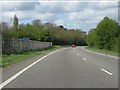
8
A40 North Way heading west
A dual carriageway bypassing Oxford to the north.
Image: © Robin Webster
Taken: 11 Aug 2019
0.17 miles
9
Houses at London Road / Barton Road junction
These houses replaced a pair of semis (#249 and #251 London Road) built diagonally on the site
Image: © Roger Templeman
Taken: 9 Sep 2015
0.18 miles
10
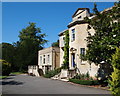
Old Headington, Oxford
Headington public library is situated in Bury Knowle House, located in the north-west corner of Bury Knowle Park. 100 yds further along this path there is an entrance/exit into North Place. Henry M. Beaufoy, Chairman of a London-based vinegar manufacturing company and his family were its last private owners. He sold the house and the park to the City Council in 1931. This public park opened in 1932 and Bury Knowle Library (re-christened Headington Library in 1999) opened in 1934. The house was built c.1800 for Joseph Lock (1760-1844), an Oxford goldsmith and banker who was Lord Mayor of Oxford in both 1813 and 1829.
Image: © David Hallam-Jones
Taken: 1 Aug 2013
0.18 miles