IMAGES TAKEN NEAR TO
Old High Street, OXFORD, OX3 9HP
Introduction
This page details the photographs taken nearby to Old High Street, OX3 9HP by members of the Geograph project.
The Geograph project started in 2005 with the aim of publishing, organising and preserving representative images for every square kilometre of Great Britain, Ireland and the Isle of Man.

There are currently over 7.5m images from over14,400 individuals and you can help contribute to the project by visiting https://www.geograph.org.uk
Image Map
Images are licensed for reuse under creativecommons.org/licenses/by-sa/2.0
Notes
- Clicking on the map will re-center to the selected point.
- The higher the marker number, the further away the image location is from the centre of the postcode.
Image Listing (178 Images Found)
Images are licensed for reuse under creativecommons.org/licenses/by-sa/2.0
Image
Details
Distance
1
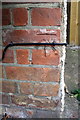
Benchmark on #26 Old High Street
Ordnance Survey cut mark benchmark described on the Bench Mark Database at http://www.bench-marks.org.uk/bm51416
Image: © Roger Templeman
Taken: 27 Sep 2013
0.02 miles
2
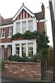
#26 Old High Street
There is an OS benchmark Image on the right front corner of the house left of the side path
Image: © Roger Templeman
Taken: 27 Sep 2013
0.02 miles
4
Headington, Oxford
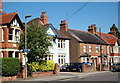
A view along the north-easterly end of Old High Street towards the junction with London Road (the A420/A40. The house on the right with the flower-bedecked window sills is the one-time home of Joy "C.S. Lewis" Davidman. Joy Davidman (1915–60), later Mrs Gresham, was an American poet and writer from New York State. At the end of a troubled marriage to her first husband, and following her conversion to Christianity, she left the USA in order to come to England with her sons. In 1950, following an introduction by a fellow American writer, Davidman had begun corresponding with C. S. Lewis and she eventually came to London in 1952. On experiencing financial difficulties C.S. Lewis found and rented this house for her and her two young sons. She lived here from 1953-57 until her death-bed marriage to C.S. Lewis, after which she and her sons moved into "The Kilns". Old Headington village is situated behind the photographer.
Image: © David Hallam-Jones
Taken: 1 Aug 2013
0.04 miles
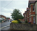
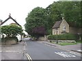
5
Headington, Oxford
This view from outside the Waitrose supermarket in Old High Street, Headington provides a view of the one-time home of Joy "C.S. Lewis". Hers was the house behind the street lamp with the plaque on its front elevation. Joy Davidman (1915–60), later Mrs Gresham, was an American poet and writer from New York State. At the end of a troubled marriage to her first husband, and following her conversion to Christianity, she left the USA in order to come to England with her sons. In 1950, following an introduction by a fellow American writer, Davidman began corresponding with C. S. Lewis and eventually came to London in 1952. On experiencing financial difficulties C.S. Lewis found and rented this house for her and her two young sons. She lived here from 1953-57 until her death-bed marriage to C.S. Lewis, after which she and her sons moved into "The Kilns".
Image: © David Hallam-Jones
Taken: 1 Aug 2013
0.05 miles
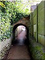
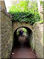
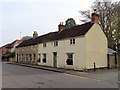
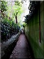
8
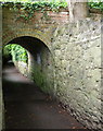
Old Headington, Oxford
This is a shot taken a few yards along Cuckoo Walk from its access point on Old High Street. The entrance behind the photographer can be located a few yards southwest of North Place, a cul-de-sac used by local people to access Bury Knowle Park. Stephanie Jenkins, a local researcher, has discovered that according to a map of this area drawn by someone associated with Corpus Christi College in 1605 that this footpath probably ran from Pullens Lane (Headington Hill) to the village of Barton (now separated from Headington by the A40, i.e. the Northern By-Pass). This section of this ancient path empties out into Osler Road ahead in approximately a mile. This almost-subterranean passage was created by William Wootten-Wootten, who bought Headington House in 1848. An ancient field that now hosts Stephen Road and part of the London Road shopping area too was part of a swathe of his land surrounding the Hall. By submerging the public right-of-way and building two narrow bridges across it for his family's use and that of his servants, it seems that he was able to continue to enjoy an uninterrupted view of his large estate whilst lesser mortals continued their journeys to and fro unobserved.
Image: © David Hallam-Jones
Taken: 1 Aug 2013
0.05 miles
10
Old High St, Headington
The blue plaque marks the home of Isaiah Berlin
Image: © John Lord
Taken: 4 Jul 2009
0.06 miles