IMAGES TAKEN NEAR TO
London Road, OXFORD, OX3 9GL
Introduction
This page details the photographs taken nearby to London Road, OX3 9GL by members of the Geograph project.
The Geograph project started in 2005 with the aim of publishing, organising and preserving representative images for every square kilometre of Great Britain, Ireland and the Isle of Man.

There are currently over 7.5m images from over14,400 individuals and you can help contribute to the project by visiting https://www.geograph.org.uk
Image Map
Images are licensed for reuse under creativecommons.org/licenses/by-sa/2.0
Notes
- Clicking on the map will re-center to the selected point.
- The higher the marker number, the further away the image location is from the centre of the postcode.
Image Listing (32 Images Found)
Images are licensed for reuse under creativecommons.org/licenses/by-sa/2.0
Image
Details
Distance
1
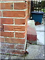
Benchmark on #501 Oxford Road
Ordnance Survey cut mark benchmark described on the Bench Mark Database at http://www.bench-marks.org.uk/bm36493
Image: © Roger Templeman
Taken: 27 Jan 2011
0.01 miles
2

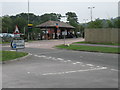
Entrance to Nielsen offices on the A40, Sandhills
Image: © David Howard
Taken: 29 Jun 2011
0.04 miles
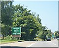
4
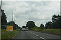
A40 towards London
Leaving the suburbs of Oxford behind.
Image: © Robin Webster
Taken: 19 Jan 2020
0.09 miles
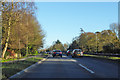
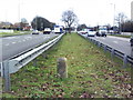
8
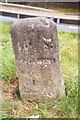
Old Milestone by London Road, Oxford
Stokenchurch pillar by the A40, in parish of Risinghurst and Sandhills (Oxford District), London Road; Sandhills Park & Ride, on central reservation, on well cut grass area, West of traffic lights.
Inscription reads:-
LI
Miles From
London
III
Miles to
Oxford
Carved benchmark on West face.
Grade II listed.
List Entry Number: 1047572 https://historicengland.org.uk/listing/the-list/list-entry/1047572
Surveyed
Milestone Society National ID: OX_lw51
Image: © Milestone Society
Taken: Unknown
0.11 miles
9
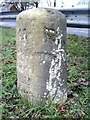
Benchmark on milestone in central reservation of A40 near Thornhill P&R
Ordnance Survey cut mark benchmark described on the Bench Mark Database at http://www.bench-marks.org.uk/bm36490
Image: © Roger Templeman
Taken: 27 Jan 2011
0.11 miles
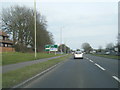
10
Milestone in the central reservation of the A40 at the approach to the Thornhill P&R
The milestone is inscribed with the distances to London (51 miles) and Oxford (3 miles)
Image: © Roger Templeman
Taken: 27 Jan 2011
0.11 miles