IMAGES TAKEN NEAR TO
St. Andrews Lane, OXFORD, OX3 9DP
Introduction
This page details the photographs taken nearby to St. Andrews Lane, OX3 9DP by members of the Geograph project.
The Geograph project started in 2005 with the aim of publishing, organising and preserving representative images for every square kilometre of Great Britain, Ireland and the Isle of Man.

There are currently over 7.5m images from over14,400 individuals and you can help contribute to the project by visiting https://www.geograph.org.uk
Image Map
Images are licensed for reuse under creativecommons.org/licenses/by-sa/2.0
Notes
- Clicking on the map will re-center to the selected point.
- The higher the marker number, the further away the image location is from the centre of the postcode.
Image Listing (119 Images Found)
Images are licensed for reuse under creativecommons.org/licenses/by-sa/2.0
Image
Details
Distance
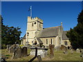
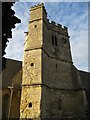
1
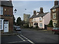
St Andrew's Church
From the Old High Street looking to the tower of St Andrew's Church
Image: © Shaun Ferguson
Taken: 20 Dec 2008
0.06 miles
2
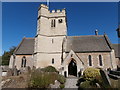
St Andrew's Church, Old Headington
I attended this church for a year or so as a teenager, and possibly overlapped at that time with Alethea, whose family I have since married into. The over-powerful organ had previously belonged to Merton College and the church was unusual in using the BBC Hymn Book. I remembered a charming interior full of character, quite unlike nearby All Saints Highfield. It looks very different inside now and the organ which replaced the one I knew is itself due for replacement. https://www.standrewsheadington.co.uk/
Image: © HelenK
Taken: 14 Sep 2019
0.07 miles
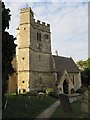
3
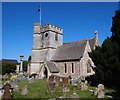
Old Headington, Oxford
The south facing aspect of the Grade II* listed St Andrew's Church, from the front of the White Hart pub opposite it. St Andrew’s Church is considered to be Headington’s oldest surviving building with some parts of it dating back to the C12th. It is considered to have been established by Hugh de Pluggenait, Lord of the Manor of Headington between 1142-1201.
Image: © David Hallam-Jones
Taken: 1 Aug 2013
0.07 miles
6
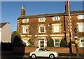
Box Tree House on St Andrew's Road
The blue plaque on the wall is to Salvador de Madariago (1886-1978). He was an Author, Scholar and a Statesman for the Spanish Republic, living in exile during the Franco era.
Image: © Steve Daniels
Taken: 2 Jan 2014
0.08 miles
7

Blue Plaque on Box Tree House
The blue plaque on the wall is to Salvador de Madariago (1886-1978). He was an Author, Scholar and a Statesman for the Spanish Republic, living in exile during the Franco era. http://www.oxfordshireblueplaques.org.uk/plaques/madariaga.html
Image: © Steve Daniels
Taken: 2 Jan 2014
0.08 miles
8
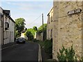
Larkins Lane
Says so on the road sign on the wall.
Image: © Bill Nicholls
Taken: 16 May 2011
0.08 miles
9
St Andrews Church
View down the footpath to St Andrews Church in Headington.
Image: © Bill Nicholls
Taken: 16 May 2011
0.08 miles
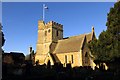
10
Clock on the tower
St Andrews Church tower with the staircase on the outside, the clock at least has not be placed over the louvres.
Image: © Bill Nicholls
Taken: 16 May 2011
0.08 miles