IMAGES TAKEN NEAR TO
Osler Road, OXFORD, OX3 9BN
Introduction
This page details the photographs taken nearby to Osler Road, OX3 9BN by members of the Geograph project.
The Geograph project started in 2005 with the aim of publishing, organising and preserving representative images for every square kilometre of Great Britain, Ireland and the Isle of Man.

There are currently over 7.5m images from over14,400 individuals and you can help contribute to the project by visiting https://www.geograph.org.uk
Image Map
Images are licensed for reuse under creativecommons.org/licenses/by-sa/2.0
Notes
- Clicking on the map will re-center to the selected point.
- The higher the marker number, the further away the image location is from the centre of the postcode.
Image Listing (159 Images Found)
Images are licensed for reuse under creativecommons.org/licenses/by-sa/2.0
Image
Details
Distance
1
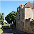
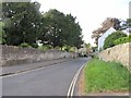
Old Headington, Oxford
A privately owned house called St Andrew's House occupying this corner site at the junction of Osler Road, on which the photographer is standing and St Andrew's Road ahead. Osler Road was named after Sir William Osler (1849-1919).
Osler was a Canadian physician who came to England in 1905 when he was appointed Regius Professor of Medicine at Oxford. Considered by many to have been one of the founders of modern medicine, he once said he hoped that his tombstone would read "I desire no other epitaph than the statement that I taught medical students in the wards, as I regard this as by far the most useful and important work I have been called upon to do."
Image: © David Hallam-Jones
Taken: 1 Aug 2013
0.03 miles
2
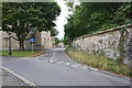
Bend in the wall
The point at which Osler Road joins St Andrews Road is right on the bend in the wall.
Image: © Bill Nicholls
Taken: 16 May 2011
0.04 miles
3
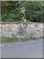
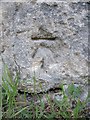
Junction of St Andrew's Road and Osler Road
There is an OS benchmark Image on a stone in the wall at the right hand edge of the image
Image: © Roger Templeman
Taken: 18 Sep 2013
0.05 miles
4
Benchmark on the join
Spotted the benchmark while walking past, it's right on the bottom stone in the wall above the one in the bank.
Image: © Bill Nicholls
Taken: 16 May 2011
0.05 miles
5
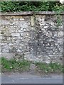
The benchmark in the wall
Close up view in the wall by Osler Road. Image
Image: © Bill Nicholls
Taken: 16 May 2011
0.05 miles
6
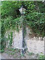
Getting lost in ivy
Ivy getting a hold on an old street light along St Andrews road in Headington.
Image: © Bill Nicholls
Taken: 16 May 2011
0.05 miles
7
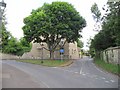
The Village triangle
Another village with a triangle, the road leading to the left is St Andrews Road and the one straight ahead is Osler Road.
Image: © Bill Nicholls
Taken: 16 May 2011
0.06 miles
8
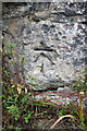
Benchmark on St Andrew's Road wall
Ordnance Survey cut mark benchmark described on the Bench Mark Database at http://www.bench-marks.org.uk/bm37962
Image: © Roger Templeman
Taken: 18 Sep 2013
0.06 miles
9
St Andrews Road to the bend
View down St Andrews road towards the bend and junction with Osler road.
Image: © Bill Nicholls
Taken: 16 May 2011
0.06 miles
10
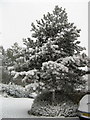
Snow Covered Tree, Laurel Farm Road, Old Headington
Image: © Helen Williams
Taken: 8 Feb 2007
0.06 miles