IMAGES TAKEN NEAR TO
Thame Road, CHINNOR, OX39 4LB
Introduction
This page details the photographs taken nearby to Thame Road, OX39 4LB by members of the Geograph project.
The Geograph project started in 2005 with the aim of publishing, organising and preserving representative images for every square kilometre of Great Britain, Ireland and the Isle of Man.

There are currently over 7.5m images from over14,400 individuals and you can help contribute to the project by visiting https://www.geograph.org.uk
Image Map
Images are licensed for reuse under creativecommons.org/licenses/by-sa/2.0
Notes
- Clicking on the map will re-center to the selected point.
- The higher the marker number, the further away the image location is from the centre of the postcode.
Image Listing (19 Images Found)
Images are licensed for reuse under creativecommons.org/licenses/by-sa/2.0
Image
Details
Distance
1
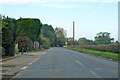
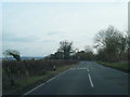
B4445 towards Thame
Leaving the fringes of Sydenham.
Image: © Robin Webster
Taken: 20 Oct 2018
0.02 miles
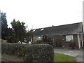

6
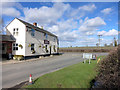
The Inn at Emmington
Country pub at a crossroads between Thame and Chinnor.
Image: © Des Blenkinsopp
Taken: 27 Feb 2015
0.08 miles
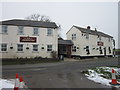
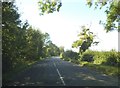
10
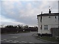
Sydenham at the junction of Thame Road
The pub is the Inn at Emmington
Image: © David Howard
Taken: 20 Mar 2016
0.09 miles