IMAGES TAKEN NEAR TO
Glimbers Grove, CHINNOR, OX39 4HE
Introduction
This page details the photographs taken nearby to Glimbers Grove, OX39 4HE by members of the Geograph project.
The Geograph project started in 2005 with the aim of publishing, organising and preserving representative images for every square kilometre of Great Britain, Ireland and the Isle of Man.

There are currently over 7.5m images from over14,400 individuals and you can help contribute to the project by visiting https://www.geograph.org.uk
Image Map
Images are licensed for reuse under creativecommons.org/licenses/by-sa/2.0
Notes
- Clicking on the map will re-center to the selected point.
- The higher the marker number, the further away the image location is from the centre of the postcode.
Image Listing (13 Images Found)
Images are licensed for reuse under creativecommons.org/licenses/by-sa/2.0
Image
Details
Distance
3
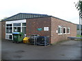
Telephone Exchange, Chinnor, Oxon
Situated down a track off Oakley Road, this TE, which has the code SMKBN, replaced the former TE in Crowell Road, Kingston Blount in the early 1970s, SU7499 refers http://www.geograph.org.uk/photo/1531254. It provides telephone and broadband services to 2,952 residential and 112 non-residential premises in Chinnor plus the villages of Aston Rowant, Crowell, Henton, Kingston Blount, Lewknor and Sydenham nearby. The post on the extreme right of the photo has two antennas on top. The numbering range of this TE is (01844) 35xxxx, the (01844) referring to the Thame group of nine TEs, and its postcode is OX39 4HX.
Image: © David Hillas
Taken: 10 Oct 2009
0.10 miles
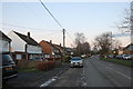
6
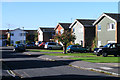
Druid's Walk, Chinnor
Houses in a cul-de-sac viewed from the junction with Glynswood.
Image: © Andrew Smith
Taken: 24 Oct 2010
0.14 miles
8
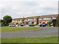
Hailey Croft, Oakley, Chinnor
On a 1940s map there is no housing in this area, and Oakley was a small village separate from Chinnor. It is now part of a much expanded small town of Chinnor.
Image: © David Hawgood
Taken: 16 Aug 2005
0.20 miles
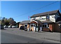
9
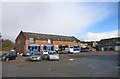
Shops, Middle Way, Chinnor
At a guess these were intended as local shops when the surrounding housing was built.
They are now trading as businesses with a wider catchment, Bathroom Sales, Costume Hire and Plumbing Supplies.
Image: © Des Blenkinsopp
Taken: 7 Oct 2014
0.21 miles
10
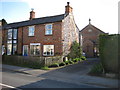
Chinnor Methodist Church
The church, which was built in 1872, is tucked away behind a couple of brick and flint cottages on Station Road, the right one of which certainly appears to be owned by the Church.
Image: © Nigel Cox
Taken: 30 Mar 2008
0.21 miles