IMAGES TAKEN NEAR TO
Crowell Hill, CHINNOR, OX39 4BT
Introduction
This page details the photographs taken nearby to Crowell Hill, OX39 4BT by members of the Geograph project.
The Geograph project started in 2005 with the aim of publishing, organising and preserving representative images for every square kilometre of Great Britain, Ireland and the Isle of Man.

There are currently over 7.5m images from over14,400 individuals and you can help contribute to the project by visiting https://www.geograph.org.uk
Image Map (5 Images)


Getting Data...Please wait
Leaflet Map data © OpenStreetMap
Images are licensed for reuse under creativecommons.org/licenses/by-sa/2.0
Notes
- Clicking on the map will re-center to the selected point.
- The higher the marker number, the further away the image location is from the centre of the postcode.
Image Listing (5 Images Found)
Images are licensed for reuse under creativecommons.org/licenses/by-sa/2.0
Image
Details
Distance
1
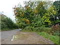
Pull-off, Chinnor Hill
A large but wet pull-off, handy for some walking routes.
Image: © Robin Webster
Taken: 18 Oct 2015
0.09 miles
2
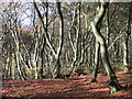
Crowell Hill Wood
Beech trees looking good for the camera as usual.
Crowell Hill Wood is one of the many woods along the steep Chiltern scarp.
Image: © Des Blenkinsopp
Taken: 11 Nov 2016
0.19 miles
3
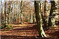
Woodland, Crowell
A footpath running along the edge of Crowellhill Wood atop the Chiltern scarp.
Image: © Andrew Smith
Taken: 25 Nov 2021
0.19 miles
4
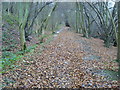
Restricted Byway heading up the hill
Restricted Byway heading up the hill in Crowellhill Wood
Image: © Shaun Ferguson
Taken: 21 Nov 2008
0.20 miles
5

Way to Crowellhill Farm and bridleway
The farm is round to the right, the bridleway to Crowell Wood and beyond goes straight on into the trees.
Image: © Robin Webster
Taken: 18 Oct 2015
0.21 miles