IMAGES TAKEN NEAR TO
Quarry Road, OXFORD, OX3 8NX
Introduction
This page details the photographs taken nearby to Quarry Road, OX3 8NX by members of the Geograph project.
The Geograph project started in 2005 with the aim of publishing, organising and preserving representative images for every square kilometre of Great Britain, Ireland and the Isle of Man.

There are currently over 7.5m images from over14,400 individuals and you can help contribute to the project by visiting https://www.geograph.org.uk
Image Map
Images are licensed for reuse under creativecommons.org/licenses/by-sa/2.0
Notes
- Clicking on the map will re-center to the selected point.
- The higher the marker number, the further away the image location is from the centre of the postcode.
Image Listing (154 Images Found)
Images are licensed for reuse under creativecommons.org/licenses/by-sa/2.0
Image
Details
Distance
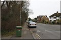
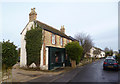
1
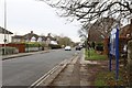
Quarry Road
Quarry Road in Headington looking towards Headington Quarry
Image: © Bill Nicholls
Taken: 9 Dec 2014
0.03 miles
2
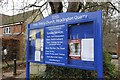
Sign near the Path
The church sign & notice board near the path leading to the church
Image: © Bill Nicholls
Taken: 9 Dec 2014
0.03 miles
3
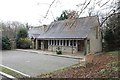
The Coach House
The coach house in Headington, used by the Holy Trinity church
Image: © Bill Nicholls
Taken: 9 Dec 2014
0.05 miles
4
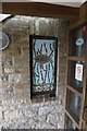
Mural at the Coach House
Looks like a fish swimming through weeds and is by the entrance to the coach house Headington
Image: © Bill Nicholls
Taken: 9 Dec 2014
0.05 miles
5
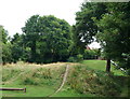
Headington Quarry, Oxford
A view of Quarry Hollow Play Area from the Quarry Hollow (road name) direction. This picture gives a good idea of the environmental impact that stone quarrying had on this surburb during the late 14th to mid 18th centuries. A substantial number of Oxford's colleges were built using Headington Stone and some colleges owned their own quarries here in this part of the city. Much of the village consists of properties built on undulating terrain, connected by narrow alleyways. This recreation area was created c.1974 In the distance, beyond the wooden directional signpost, another entrance/exit exists joining Quarry Road.
Image: © David Hallam-Jones
Taken: 1 Aug 2013
0.05 miles
6
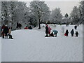
Quarry Hollow Play Area with children playing in the snow
This old quarry was known locally as Munts's, the name of the builder whose yard it was when he built many of the houses in the area in the 1920s.
Image: © David Barrington
Taken: 6 Jan 2010
0.05 miles
7
Quarry Road Headington
Quarry Road looking towards New Headington
Image: © Bill Nicholls
Taken: 9 Dec 2014
0.06 miles
8
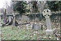
Graves by the Wall
Some of the graves near the west perimeter wall at the Holy Trinity Headington
Image: © Bill Nicholls
Taken: 9 Dec 2014
0.06 miles
9
Quarry High Street
The old village of Headington Quarry grew up around the stone working industry and is distinctly different from newer, suburban Headington.
The shop here looks a bit closed but is still in business as a musical instrument
repair workshop.
Image: © Des Blenkinsopp
Taken: 28 Jan 2013
0.06 miles
10
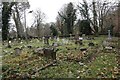
Holy Trinity Churchyard
The Churchyard over to south of the church looking south
Image: © Bill Nicholls
Taken: 9 Dec 2014
0.06 miles