IMAGES TAKEN NEAR TO
Shelley Close, OXFORD, OX3 8HB
Introduction
This page details the photographs taken nearby to Shelley Close, OX3 8HB by members of the Geograph project.
The Geograph project started in 2005 with the aim of publishing, organising and preserving representative images for every square kilometre of Great Britain, Ireland and the Isle of Man.

There are currently over 7.5m images from over14,400 individuals and you can help contribute to the project by visiting https://www.geograph.org.uk
Image Map
Images are licensed for reuse under creativecommons.org/licenses/by-sa/2.0
Notes
- Clicking on the map will re-center to the selected point.
- The higher the marker number, the further away the image location is from the centre of the postcode.
Image Listing (143 Images Found)
Images are licensed for reuse under creativecommons.org/licenses/by-sa/2.0
Image
Details
Distance
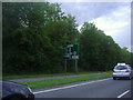
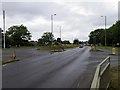
1
The Eastern By-Pass Road in Headington
Image: © Steve Daniels
Taken: 19 Jun 2020
0.07 miles
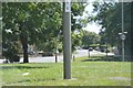
2
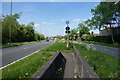
Path across the Oxford Ring Road
You have to walk across both carriageways, but there are gaps in the traffic.
Image: © Bill Boaden
Taken: 3 May 2014
0.09 miles
3
The Eastern By-Pass Road in Headington
Image: © Steve Daniels
Taken: 19 Jun 2020
0.09 miles
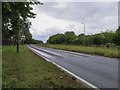
5
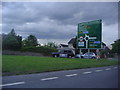
Approaching Headington Roundabout on the Ring Road
Image: © David Howard
Taken: 29 Jun 2011
0.10 miles

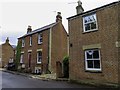
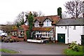
8
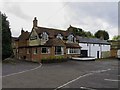
The Six Bells on Beaumont Road
The Six Bells is a former Morrells pub.
Image: © Steve Daniels
Taken: 19 Jun 2020
0.13 miles