IMAGES TAKEN NEAR TO
The Link, OXFORD, OX3 8DU
Introduction
This page details the photographs taken nearby to The Link, OX3 8DU by members of the Geograph project.
The Geograph project started in 2005 with the aim of publishing, organising and preserving representative images for every square kilometre of Great Britain, Ireland and the Isle of Man.

There are currently over 7.5m images from over14,400 individuals and you can help contribute to the project by visiting https://www.geograph.org.uk
Image Map
Images are licensed for reuse under creativecommons.org/licenses/by-sa/2.0
Notes
- Clicking on the map will re-center to the selected point.
- The higher the marker number, the further away the image location is from the centre of the postcode.
Image Listing (44 Images Found)
Images are licensed for reuse under creativecommons.org/licenses/by-sa/2.0
Image
Details
Distance
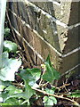
1
Benchmark on #12 Ridgeway Road
Ordnance Survey cut mark benchmark described on the Bench Mark Database at http://www.bench-marks.org.uk/bm37424
Image: © Roger Templeman
Taken: 28 Mar 2011
0.05 miles
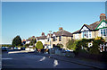
2
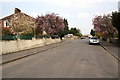
Junction of Forest Road with Ridgeway Road
The beech hedge visible past the end of the road is on the north side of the A40.
Image: © Roger Templeman
Taken: 28 Mar 2011
0.05 miles
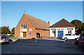
4
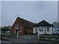
Church and Library
The view of the United Reformed Church in Risinghurst, Oxford.
Image: © Gordon Griffiths
Taken: 28 Dec 2024
0.08 miles
5
Ridgeway Road, Roman?
The course of the Roman road between Bicester and Dorchester has been lost and built over through this part of East Oxford.
But by projecting the line from the known sections of road the likely course can be estimated, and it goes more or less along here.
Entirely coincidental I'm sure, but why spoil a good story.
Image: © Des Blenkinsopp
Taken: 10 Oct 2012
0.10 miles
6
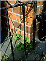
Benchmark on #320 London Road
Ordnance Survey cut mark benchmark described on the Bench Mark Database at http://www.bench-marks.org.uk/bm37455
Image: © Roger Templeman
Taken: 28 Mar 2011
0.11 miles
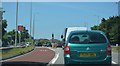
9
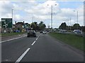
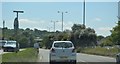
A40 approaching Headington roundabout
The through route north and west across the roundabout is clearly signed. This is not the Oxford of dreaming spires and contemplation; rather suburbia and commuter belt.
Image: © Peter Whatley
Taken: 12 Apr 2011
0.14 miles