IMAGES TAKEN NEAR TO
OX3 7YU
Introduction
This page details the photographs taken nearby to OX3 7YU by members of the Geograph project.
The Geograph project started in 2005 with the aim of publishing, organising and preserving representative images for every square kilometre of Great Britain, Ireland and the Isle of Man.

There are currently over 7.5m images from over14,400 individuals and you can help contribute to the project by visiting https://www.geograph.org.uk
Image Map
Images are licensed for reuse under creativecommons.org/licenses/by-sa/2.0
Notes
- Clicking on the map will re-center to the selected point.
- The higher the marker number, the further away the image location is from the centre of the postcode.
Image Listing (51 Images Found)
Images are licensed for reuse under creativecommons.org/licenses/by-sa/2.0
Image
Details
Distance
1
Junction of Old Road and Lime Walk
There is an OS benchmark Image on the brick wall about 2m to the right of the junction of the low and high parts
Image: © Roger Templeman
Taken: 27 Sep 2013
0.02 miles
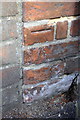
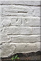
2
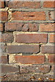
Benchmark on Old Road wall near Lime Walk junction
Ordnance Survey cut mark benchmark described on the Bench Mark Database at http://www.bench-marks.org.uk/bm51418
Image: © Roger Templeman
Taken: 27 Sep 2013
0.02 miles
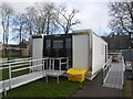
4
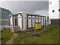
Coronavirus testing centre
Oxford University early alert testing service at the Old Road campus. This shows the exits at the back of the structure. The temporary building is surrounded by fences and a large yellow wheelie bin.
Image: © Pierre Marshall
Taken: 19 Dec 2020
0.07 miles
5
Coronavirus testing centre
Oxford University early alert testing service at the Old Road campus.
This is the second rapid testing centre in Oxford, although most students have gone home now and I'm not sure these temporary structures are in active use at the moment.
Image: © Pierre Marshall
Taken: 19 Dec 2020
0.08 miles
6
Benchmark on wall of #67 Old Road
Ordnance Survey cut mark benchmark described on the Bench Mark Database at http://www.bench-marks.org.uk/bm24707
Image: © Roger Templeman
Taken: 27 Sep 2013
0.09 miles
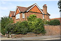
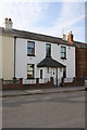
7
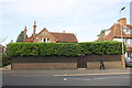
#67 Old Road
There is an OS benchmark Image on the wall pier at the right hand side of the image behind the lamp post
Image: © Roger Templeman
Taken: 27 Sep 2013
0.09 miles
9
Benchmark on #104 Lime Walk
Ordnance Survey cut mark benchmark described on the Bench Mark Database at http://www.bench-marks.org.uk/bm24696
Image: © Roger Templeman
Taken: 27 Sep 2013
0.10 miles
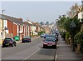
10
#104 Lime Walk, 'Eventide'
There is an OS benchmark Image on the side of the house above the alleyway between the house and the house to its right, #102
Image: © Roger Templeman
Taken: 27 Sep 2013
0.10 miles