IMAGES TAKEN NEAR TO
London Road, OXFORD, OX3 7SP
Introduction
This page details the photographs taken nearby to London Road, OX3 7SP by members of the Geograph project.
The Geograph project started in 2005 with the aim of publishing, organising and preserving representative images for every square kilometre of Great Britain, Ireland and the Isle of Man.

There are currently over 7.5m images from over14,400 individuals and you can help contribute to the project by visiting https://www.geograph.org.uk
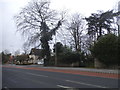
Image Map
Images are licensed for reuse under creativecommons.org/licenses/by-sa/2.0
Notes
- Clicking on the map will re-center to the selected point.
- The higher the marker number, the further away the image location is from the centre of the postcode.
Image Listing (82 Images Found)
Images are licensed for reuse under creativecommons.org/licenses/by-sa/2.0
Image
Details
Distance
1
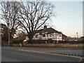
London Road Headington
Looking towards the White Horse pub
Image: © David Howard
Taken: 21 Feb 2016
0.02 miles
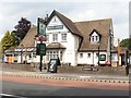
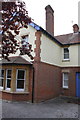
3
The White Horse on London Road
The White Horse is a Hungry Horse pub.
Image: © Steve Daniels
Taken: 18 Apr 2019
0.04 miles
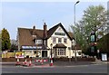
4
The White Horse in Headington
The White Horse is a former Morrells pub.
Image: © Steve Daniels
Taken: 2 Jan 2014
0.04 miles
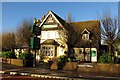
5
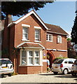
Guest house on London Road, Headington
We stayed in Pickwick's guest house here for a couple of nights. It was convenient for buses to the centre of Oxford, and also for friends we were meeting off a coach from London. And we were able to sit in a pleasant garden at the back. So it suited us well.
Image: © David Hawgood
Taken: 4 Jul 2009
0.06 miles
6
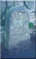
Old Boundary Marker by the A420, Headington Road, Oxford Parish
Parish Boundary Marker by the A420, in parish of Oxford (Oxford District), Headington Road; in front of No.238, beside traffic lights, by junction with Brookside, set in pavement by low stone wall.
Surveyed
Milestone Society National ID: OX_LW52pb
Image: © Milestone Society
Taken: Unknown
0.07 miles
8
#12 Sandfield Road
There is an OS benchmark Image on the bricks left of the blue garage door
Image: © Roger Templeman
Taken: 18 Sep 2013
0.09 miles
9
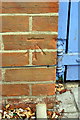
Benchmark on #12 Sandfield Road
Ordnance Survey cut mark benchmark described on the Bench Mark Database at http://www.bench-marks.org.uk/bm51651
Image: © Roger Templeman
Taken: 18 Sep 2013
0.09 miles
10
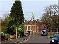
Looking along Valentia Road to Headington Girls' School
Image: © Steve Daniels
Taken: 18 Apr 2019
0.09 miles