IMAGES TAKEN NEAR TO
Sandfield Road, OXFORD, OX3 7RH
Introduction
This page details the photographs taken nearby to Sandfield Road, OX3 7RH by members of the Geograph project.
The Geograph project started in 2005 with the aim of publishing, organising and preserving representative images for every square kilometre of Great Britain, Ireland and the Isle of Man.

There are currently over 7.5m images from over14,400 individuals and you can help contribute to the project by visiting https://www.geograph.org.uk
Image Map
Images are licensed for reuse under creativecommons.org/licenses/by-sa/2.0
Notes
- Clicking on the map will re-center to the selected point.
- The higher the marker number, the further away the image location is from the centre of the postcode.
Image Listing (90 Images Found)
Images are licensed for reuse under creativecommons.org/licenses/by-sa/2.0
Image
Details
Distance
1

Cuckoo Lane in Headington
The flats are built on the site of the Manor Ground, former home of Oxford United F.C.
Image: © Steve Daniels
Taken: 18 Apr 2019
0.06 miles
2
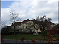
The Manor House in Headington
Originally built in the late C18, the house and its estate were purchased in 1919 by the Radcliffe Infirmary. The manor became a nursing school and subsequently offices while the portion of the estate that was not sold off for housing development have been used for new hospital development.
This is the view when approaching from Osler Road, itself named after Sir William Osler (1849-1919), Regius Professor of Medicine.
Image: © Natasha Ceridwen de Chroustchoff
Taken: 1 Mar 2009
0.07 miles
3

Cuckoo Lane in Headington
The flats are built on the site of the Manor Ground, former home of Oxford United F.C.
Image: © Steve Daniels
Taken: 18 Apr 2019
0.07 miles

5
Cuckoo Lane in Headington
The flats are built on the site of the Manor Ground, former home of Oxford United F.C.
Image: © Steve Daniels
Taken: 18 Apr 2019
0.08 miles
6
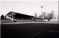
The Manor Ground
The Manor Ground was home to Oxford United.
Image: © Steve Daniels
Taken: 27 Dec 1987
0.09 miles
7

The Beech Road stand at the Manor Ground
Image: © Steve Daniels
Taken: 17 Apr 2001
0.09 miles
8
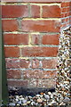
Benchmark on #40 Sandfield Road
Ordnance Survey cut mark benchmark described on the Bench Mark Database at http://www.bench-marks.org.uk/bm51649
Image: © Roger Templeman
Taken: 18 Sep 2013
0.09 miles
9

The Manor Hospital in Beech Road
The Manor Hospital is built on the site of the Manor Ground, former home of Oxford United F.C.
Image: © Steve Daniels
Taken: 18 Apr 2019
0.09 miles
10
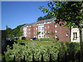
Manor Park flats
These flats were built on the 'away end' of the Oxford United Football Ground after it was sold. The OS map still shows the football pitch and not the new development which also includes the new Manor Hospital.
Update 2022: the OS map now shows the new development.
Image: © Penny Clark
Taken: 3 Jun 2006
0.10 miles