IMAGES TAKEN NEAR TO
Horspath Driftway, OXFORD, OX3 7JN
Introduction
This page details the photographs taken nearby to Horspath Driftway, OX3 7JN by members of the Geograph project.
The Geograph project started in 2005 with the aim of publishing, organising and preserving representative images for every square kilometre of Great Britain, Ireland and the Isle of Man.

There are currently over 7.5m images from over14,400 individuals and you can help contribute to the project by visiting https://www.geograph.org.uk
Image Map
Images are licensed for reuse under creativecommons.org/licenses/by-sa/2.0
Notes
- Clicking on the map will re-center to the selected point.
- The higher the marker number, the further away the image location is from the centre of the postcode.
Image Listing (23 Images Found)
Images are licensed for reuse under creativecommons.org/licenses/by-sa/2.0
Image
Details
Distance
1
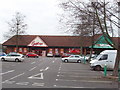
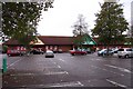
Retail Park at Cowley
A small retail park off Horspath Driftway.
Image: © David Hawgood
Taken: 30 Jan 2007
0.04 miles


5
The junction of the Eastern Bypass and Horspath Driftway
Image: © Steve Daniels
Taken: 12 Nov 2009
0.08 miles
6
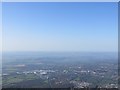
Towards Cowley
Looking towards the BMW works at Cowley with the eastern bypass running through it, in the distance you should be able to make out Didcot Powerstation
Image: © Bill Nicholls
Taken: 15 Apr 2015
0.10 miles

8
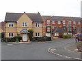
Troy Close, Cowley
A new housing estate.
Image: © David Hawgood
Taken: 30 Jan 2007
0.11 miles

10

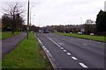
A4142 Eastern Bypass Road
Going anticlockwise around Oxford.
Image: © Robin Webster
Taken: 11 Aug 2019
0.14 miles