IMAGES TAKEN NEAR TO
Bulan Road, OXFORD, OX3 7HU
Introduction
This page details the photographs taken nearby to Bulan Road, OX3 7HU by members of the Geograph project.
The Geograph project started in 2005 with the aim of publishing, organising and preserving representative images for every square kilometre of Great Britain, Ireland and the Isle of Man.

There are currently over 7.5m images from over14,400 individuals and you can help contribute to the project by visiting https://www.geograph.org.uk
Image Map
Images are licensed for reuse under creativecommons.org/licenses/by-sa/2.0
Notes
- Clicking on the map will re-center to the selected point.
- The higher the marker number, the further away the image location is from the centre of the postcode.
Image Listing (27 Images Found)
Images are licensed for reuse under creativecommons.org/licenses/by-sa/2.0
Image
Details
Distance
1
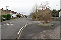
Trees at the end of Coverley Road
The centrepiece of the Lye Valley estate.
Image: © Bill Boaden
Taken: 4 Dec 2020
0.07 miles
2
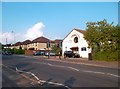
Hollow Way, Cowley
The church is dedicated to St Francis.
Image: © Des Blenkinsopp
Taken: 29 May 2012
0.09 miles


7
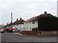
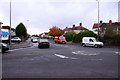
Houses on Town Furze, Headington
At the junction with Glebelands.
Image: © David Hawgood
Taken: 30 Jan 2007
0.12 miles
8
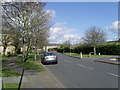
The beginning of Three Fields Road
This shot was taken as you enter Three Fields Road. On the right you can see the road turning for Stubbs Avenue.
Image: © Michael Holden
Taken: 11 Apr 2008
0.13 miles

10

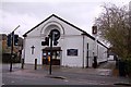
Slade Park (Oxford) fire station
Slade Park (Oxford) fire station, Horspath Driftway, Headington, Oxfordshire
Image: © Kevin Hale
Taken: 5 Oct 2007
0.14 miles