IMAGES TAKEN NEAR TO
Piper Street, OXFORD, OX3 7AR
Introduction
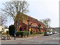
This page details the photographs taken nearby to Piper Street, OX3 7AR by members of the Geograph project.
The Geograph project started in 2005 with the aim of publishing, organising and preserving representative images for every square kilometre of Great Britain, Ireland and the Isle of Man.

There are currently over 7.5m images from over14,400 individuals and you can help contribute to the project by visiting https://www.geograph.org.uk
Image Map
Images are licensed for reuse under creativecommons.org/licenses/by-sa/2.0
Notes
- Clicking on the map will re-center to the selected point.
- The higher the marker number, the further away the image location is from the centre of the postcode.
Image Listing (90 Images Found)
Images are licensed for reuse under creativecommons.org/licenses/by-sa/2.0
Image
Details
Distance
1
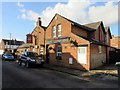
The Butchers Arms in Wilberforce Street
Image: © Steve Daniels
Taken: 7 Feb 2017
0.02 miles
2
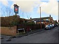
The Butchers Arms in Wilberforce Street
Image: © Steve Daniels
Taken: 7 Feb 2017
0.03 miles
3
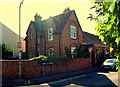
New Headington, Oxford
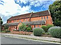
A former headmistress's house and the former New Headington Infants' School at the junction of Windsor Street and Perrin Street. The new school attracted 60-100 fee-paying children of between 3-6 years of age and functioned between 1837- 1908. (The charge for each child was a penny a week). Together with the headmistress’s house, the school cost £3,50l to build. Once old enough, the children moved up to Headington National School (now St Andrew's Primary School) on the London Road. The school closed after 34 years when Headington's first council school opened in Margaret Road, once the headmistress and her flock had transferred there. The building has been used almost continually since then by Guide and Brownie groups and by various commercial firms but is now standing empty and awaiting redevelopment.
Image: © David Hallam-Jones
Taken: 1 Aug 2013
0.04 miles
4
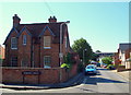
New Headington, Oxford
A former school house at the junction of Windsor Street and Perrin Street. The Headmistress of the former New Headington Infant School, behind the house, lived here. The new school attracted 60-100 fee-paying children of between 3-6 years of age and functioned between 1837- 1908. (The charge for each child was a penny a week). Together with the headmistress’s house, the school cost £3,50l to build. Once old enough, the children moved up to Headington National School (now St Andrew's Primary School) on the London Road. The school closed after 34 years when Headington's first council school opened in Margaret Road, once the headmistress and her flock had transferred there. The building has been used almost continually since then by Guide and Brownie groups and by various commercial firms but is now standing empty and awaiting redevelopment.
Image: © David Hallam-Jones
Taken: 1 Aug 2013
0.04 miles
5
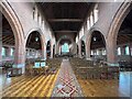
Looking along the Nave
Looking down the nave in All Saints Headington showing the north and south aisles
Image: © Bill Nicholls
Taken: 12 Jul 2023
0.07 miles
6
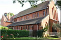
All Saints Church
All Saints church from All Saints Road in Headington
Image: © Bill Nicholls
Taken: 12 Jul 2023
0.07 miles
7
All Saints Church, Lime Walk
There is an OS benchmark Image on the buttress on the near corner
Image: © Roger Templeman
Taken: 27 Sep 2013
0.08 miles
8
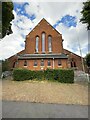
All Saints Headington
The west end of All Saints Headington
Image: © Bill Nicholls
Taken: 12 Jul 2023
0.08 miles
10
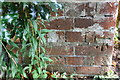
Benchmark on buttress of All Saints Church
Ordnance Survey cut mark benchmark described on the Bench Mark Database at http://www.bench-marks.org.uk/bm24695
Image: © Roger Templeman
Taken: 27 Sep 2013
0.09 miles