IMAGES TAKEN NEAR TO
Fane Road, OXFORD, OX3 0SA
Introduction
This page details the photographs taken nearby to Fane Road, OX3 0SA by members of the Geograph project.
The Geograph project started in 2005 with the aim of publishing, organising and preserving representative images for every square kilometre of Great Britain, Ireland and the Isle of Man.

There are currently over 7.5m images from over14,400 individuals and you can help contribute to the project by visiting https://www.geograph.org.uk
Image Map
Images are licensed for reuse under creativecommons.org/licenses/by-sa/2.0
Notes
- Clicking on the map will re-center to the selected point.
- The higher the marker number, the further away the image location is from the centre of the postcode.
Image Listing (6 Images Found)
Images are licensed for reuse under creativecommons.org/licenses/by-sa/2.0
Image
Details
Distance

2

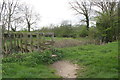
Footpath by Marston Brook
This footpath follows the edge of the Marston suburb on Arlington Drive. Marston Brook is a tiny ditch on the left which eventually runs into the River Cherwell.
Image: © Bill Boaden
Taken: 25 Jun 2010
0.11 miles
3

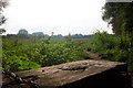
Path by Marston Brook
A remarkably peaceful rural view only a couple of kilometres from Oxford City Centre.
Image: © Bill Boaden
Taken: 25 Jun 2010
0.13 miles
4
Footbridge over Marston Brook at footpath junction
Image: © Roger Templeman
Taken: 12 Apr 2014
0.22 miles