IMAGES TAKEN NEAR TO
Mortimer Drive, OXFORD, OX3 0RS
Introduction
This page details the photographs taken nearby to Mortimer Drive, OX3 0RS by members of the Geograph project.
The Geograph project started in 2005 with the aim of publishing, organising and preserving representative images for every square kilometre of Great Britain, Ireland and the Isle of Man.

There are currently over 7.5m images from over14,400 individuals and you can help contribute to the project by visiting https://www.geograph.org.uk
Image Map
Images are licensed for reuse under creativecommons.org/licenses/by-sa/2.0
Notes
- Clicking on the map will re-center to the selected point.
- The higher the marker number, the further away the image location is from the centre of the postcode.
Image Listing (17 Images Found)
Images are licensed for reuse under creativecommons.org/licenses/by-sa/2.0
Image
Details
Distance


4

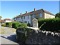
A pair of semi-detached houses on Croft Road
There is an OS benchmark Image on the side of the left hand house at its front corner
Image: © Roger Templeman
Taken: 24 Mar 2014
0.18 miles
5

Benchmark on #71 Croft Road
Ordnance Survey cut mark benchmark described on the Bench Mark Database at http://www.bench-marks.org.uk/bm55957
Image: © Roger Templeman
Taken: 24 Mar 2014
0.19 miles
6
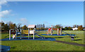
Playground in the Park
Part of a large area of flat, open land between the houses and the River Cherwell.
Image: © Des Blenkinsopp
Taken: 7 Nov 2012
0.20 miles
7
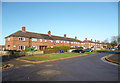
Croft Road, New Marston
This road was built in 1935. Each block has a carefully made date plaque similar to the one shown here Image
Image: © Des Blenkinsopp
Taken: 7 Nov 2012
0.21 miles
8

Footpath by Marston Brook
This footpath follows the edge of the Marston suburb on Arlington Drive. Marston Brook is a tiny ditch on the left which eventually runs into the River Cherwell.
Image: © Bill Boaden
Taken: 25 Jun 2010
0.22 miles
9

Churchill Drive, Old Marston
A lucky diversion while the bypass was closed got me into some new Oxford territory.
Image: © David Howard
Taken: 23 May 2020
0.22 miles
10

Where Oxford Road meets Cherwell Drive
Cherwell Drive is the major road, and Oxford Road joins it from the left. Despite the name, Oxford Road is a residential street which doesn't go anywhere.
Image: © Bill Boaden
Taken: 25 Jun 2010
0.23 miles