IMAGES TAKEN NEAR TO
Park Way, OXFORD, OX3 0QH
Introduction
This page details the photographs taken nearby to Park Way, OX3 0QH by members of the Geograph project.
The Geograph project started in 2005 with the aim of publishing, organising and preserving representative images for every square kilometre of Great Britain, Ireland and the Isle of Man.

There are currently over 7.5m images from over14,400 individuals and you can help contribute to the project by visiting https://www.geograph.org.uk
Image Map
Images are licensed for reuse under creativecommons.org/licenses/by-sa/2.0
Notes
- Clicking on the map will re-center to the selected point.
- The higher the marker number, the further away the image location is from the centre of the postcode.
Image Listing (137 Images Found)
Images are licensed for reuse under creativecommons.org/licenses/by-sa/2.0
Image
Details
Distance
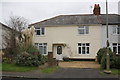
2
Houses in Mill Lane, Old Marston
Mill Lane is quiet as it has no entry onto the Northern Bypass.
Image: © David Hawgood
Taken: 13 Feb 2007
0.07 miles
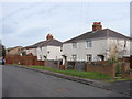
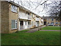
3
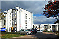
Bradlands, Old Marston
I had a "have I got it wrong" moment when submitting this one and finding Image in the same place. But it seems the fairly recent housing that was here before has been demolished and replaced by these new blocks.
Image: © Des Blenkinsopp
Taken: 1 Oct 2018
0.07 miles
5
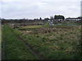
Allotments off Mill Lane
Allotments of Mill Lane up to the Northern Bypass
Image: © Shaun Ferguson
Taken: 20 Dec 2008
0.10 miles
6
Bradlands, Old Marston
This is a development by Oxford City Council Housing Services.
Image: © David Hawgood
Taken: 13 Feb 2007
0.10 miles
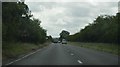
7
Mill Lane allotments
A kilometre square bisected by the Oxford northern by-pass and devoid of much interest.
Image: © Gerry Lewis
Taken: 15 Feb 2007
0.11 miles
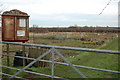
9
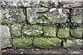
Benchmark on boundary wall of #17 Mill Lane
Ordnance Survey cut mark benchmark described on the Bench Mark Database at http://www.bench-marks.org.uk/bm46700
Image: © Roger Templeman
Taken: 7 Jan 2013
0.12 miles
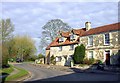
10
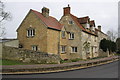
#17 and the Manor House, Mill Lane
There is an OS benchmark Image on a stone in the wall at its bend.
Image: © Roger Templeman
Taken: 7 Jan 2013
0.12 miles