IMAGES TAKEN NEAR TO
Ferry Road, OXFORD, OX3 0HA
Introduction
This page details the photographs taken nearby to Ferry Road, OX3 0HA by members of the Geograph project.
The Geograph project started in 2005 with the aim of publishing, organising and preserving representative images for every square kilometre of Great Britain, Ireland and the Isle of Man.

There are currently over 7.5m images from over14,400 individuals and you can help contribute to the project by visiting https://www.geograph.org.uk
Image Map
Images are licensed for reuse under creativecommons.org/licenses/by-sa/2.0
Notes
- Clicking on the map will re-center to the selected point.
- The higher the marker number, the further away the image location is from the centre of the postcode.
Image Listing (45 Images Found)
Images are licensed for reuse under creativecommons.org/licenses/by-sa/2.0
Image
Details
Distance
1
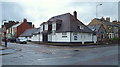
New Marston, Oxford
This huge scout hut, with its main entrance on William Street, seems to dwarf the small Sant Nirankari Satsang Bhawan on Marston Road (the B4150 road). Turning right, in front of this small "Universal Brotherhood Mission" temple leads to the city centre, via London Place and St Clement's Street.
Image: © David Hallam-Jones
Taken: 31 Jul 2013
0.02 miles
2
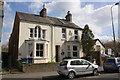
New Marston, Oxford
The small Sant Nirankari Satsang Bhawan and some housing on Marston Road (the B4150 road). Beyond these properties, behind the trees is the local Junior and Infants' School. Continuing right, this road leads into the city centre, via London Place and St Clement's Street.
Image: © David Hallam-Jones
Taken: 31 Jul 2013
0.02 miles
4
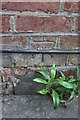
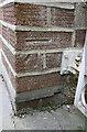
Benchmark on #230 Marston Road
Ordnance Survey cut mark benchmark described on the Bench Mark Database at http://www.bench-marks.org.uk/bm29476
Image: © Roger Templeman
Taken: 24 Mar 2014
0.03 miles
5
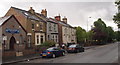
#230 and #228 Marston Road
There is an OS benchmark Image on the side of the left hand house near its front corner
Image: © Roger Templeman
Taken: 24 Mar 2014
0.03 miles

8
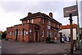
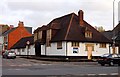
New Marston, Oxford
A Russian Orthodox Church in Ferry Road. An Orthodox congregation worships here as a result of a split from some other members of the Russian Orthodox community in Oxford who voted to move from the jurisdiction of the Patriarchate of Moscow to the Patriarchate of Constantinople in the mid-2000s. As a result of this, a separate parish - St Nicholas the Wonderworker - was established in 2006 and after a number of years of having to rent worship space elsewhere, the community acquired this disused Anglican church in 2010 and renovated it as their church. Marston Road, i.e. the B4150, lies 3-4 minute's walk ahead.
Image: © David Hallam-Jones
Taken: 31 Jul 2013
0.10 miles
9

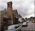
A pair of semis on Marston Road
There is an OS benchmark Image on the side of the right hand house beside the white metal gates
Image: © Roger Templeman
Taken: 24 Mar 2014
0.10 miles
10
Benchmark on #275 Marston Road
Ordnance Survey cut mark benchmark described on the Bench Mark Database at http://www.bench-marks.org.uk/bm56082
Image: © Roger Templeman
Taken: 24 Mar 2014
0.10 miles